Home > North America > United States of America > Maps
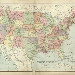
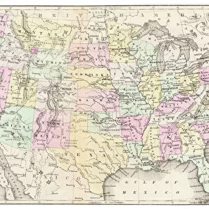
Antique Map of Western USA

![]()
Wall Art and Photo Gifts from Fine Art Storehouse
Antique Map of Western USA
Antique Map from 1867 of Western United States of America
Unleash your creativity and transform your space into a visual masterpiece!
duncan1890
Media ID 13666591
© Duncan Walker
American Culture Arizona California Chart Colorado Equipment Gulf Coast States Idaho Montana Montana Western Usa Navigational Equipment Nevada New Mexico North America Oklahoma Oregon Oregon Us State Pacific Northwest Past Retro Revival Southwest Usa Styles Texas The Americas Traditional Culture Utah Washington State Western Usa Wyoming Image Created 19th Century Obsolete Retro Styled Victorian Style
FEATURES IN THESE COLLECTIONS
> Fine Art Storehouse
> Map
> Historical Maps
> Fine Art Storehouse
> Map
> USA Maps
> Maps and Charts
> Early Maps
> North America
> Mexico
> Related Images
> North America
> United States of America
> Arizona
> Related Images
> North America
> United States of America
> California
> Related Images
> North America
> United States of America
> Colorado
> Related Images
> North America
> United States of America
> Idaho
> Related Images
> North America
> United States of America
> Maps
> North America
> United States of America
> Montana
> Related Images
> North America
> United States of America
> Nevada
> Related Images
EDITORS COMMENTS
This print takes us on a journey back in time to the vast and unexplored Western United States of America in 1867. The Antique Map of Western USA, with its retro revival style, showcases the intricate details and artistry of 19th-century cartography. Engraved with precision and painted with vibrant colors, this image captures the essence of a bygone era. As we gaze upon this antique masterpiece, we are transported to a world where navigational equipment was essential for exploration and discovery. The map highlights states such as California, Nevada, Utah, Montana, Idaho, Colorado, Wyoming, Oklahoma, Texas, Washington State, Oregon – encompassing the Pacific Northwest region – New Mexico and Arizona from the Southwest USA. The Victorian-style illustration evokes a sense of nostalgia for American culture during this period. It serves as a reminder of our rich history and traditional values that have shaped our nation over time. With no people present in the image itself but rather focusing solely on landscapes and geographical features; it allows us to appreciate the beauty of these untouched territories before they were transformed by human development. Duncan1890's skillful photography has captured every minute detail of this 19th-century treasure. This print is not just an artwork; it is an invitation to explore forgotten lands through visual storytelling. Let yourself be captivated by this timeless piece that celebrates both artistry and historical significance
MADE IN THE USA
Safe Shipping with 30 Day Money Back Guarantee
FREE PERSONALISATION*
We are proud to offer a range of customisation features including Personalised Captions, Color Filters and Picture Zoom Tools
SECURE PAYMENTS
We happily accept a wide range of payment options so you can pay for the things you need in the way that is most convenient for you
* Options may vary by product and licensing agreement. Zoomed Pictures can be adjusted in the Cart.