Home > North America > United States of America > New York > New York > Maps
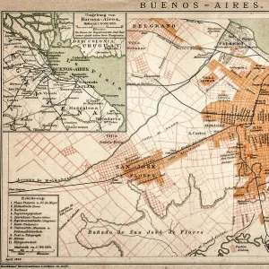
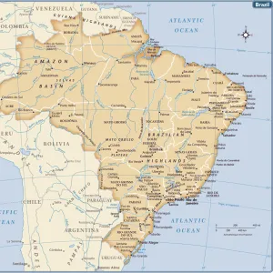
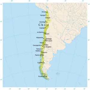
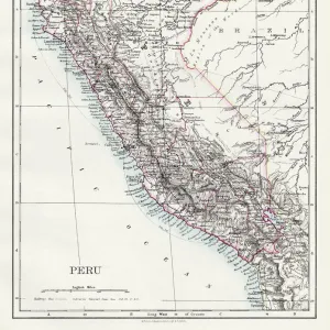
South America map 1893

![]()
Wall Art and Photo Gifts from Fine Art Storehouse
South America map 1893
Johnsonas Universal Cyclopedia - Charles Kendall - New York 1893
Unleash your creativity and transform your space into a visual masterpiece!
THEPALMER
Media ID 14756570
© This content is subject to copyright
Argentina Brazil Chile Peru South America Latinamerica
FEATURES IN THESE COLLECTIONS
> Fine Art Storehouse
> Map
> Historical Maps
> Maps and Charts
> Early Maps
> North America
> United States of America
> New York
> New York
> Maps
> South America
> Argentina
> Maps
> South America
> Brazil
> Maps
> South America
> Chile
> Maps
> South America
> Peru
> Maps
EDITORS COMMENTS
This print of the "South America map 1893" takes us on a journey back in time to explore the intricate details and rich history of this diverse continent. The map, sourced from Johnson's Universal Cyclopedia by Charles Kendall, showcases South America as it was perceived in 1893, offering a fascinating glimpse into its political boundaries and geographical features. The artist behind this remarkable print, known as THEPALMER, has skillfully captured every nuance of this vintage map with precision and clarity. From the rugged Andes Mountains that stretch across several countries to the vast Amazon rainforest teeming with life, each element is meticulously rendered. As we delve deeper into the image, our eyes are drawn to specific regions such as Chile with its long coastline hugging the Pacific Ocean or Peru boasting ancient ruins like Machu Picchu. Argentina stands out with its expansive pampas grasslands while Brazil entices us with its lush tropical landscapes and iconic landmarks like Rio de Janeiro's Christ the Redeemer statue. This artwork serves not only as a decorative piece but also as an educational tool that sparks curiosity about South America's past. It invites us to reflect on how borders may have shifted over time and encourages exploration of cultural diversity within these nations. THEPALMER's rendition of this historical map transports us back more than a century ago when cartography was both an art form and a means for understanding our world. With meticulous attention to detail, they have created an exquisite print that will surely captivate
MADE IN THE USA
Safe Shipping with 30 Day Money Back Guarantee
FREE PERSONALISATION*
We are proud to offer a range of customisation features including Personalised Captions, Color Filters and Picture Zoom Tools
SECURE PAYMENTS
We happily accept a wide range of payment options so you can pay for the things you need in the way that is most convenient for you
* Options may vary by product and licensing agreement. Zoomed Pictures can be adjusted in the Cart.