Fraud Blocker Skip to main content

Home > Asia > India > Maps
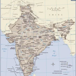
Map of India 1900

 : Map of India 1900
Sold 1
In Stock
We accept all major payment options so you can pay for the things you need in the way that is most convenient for you

Choose Your Product

Framed Photos
Buy from $79.99
Photo Prints
Buy from $9.99
Jigsaw Puzzles
Buy from $39.99
Poster Prints
Buy from $24.99
Canvas Prints
Buy from $99.99
Fine Art Prints
Buy from $60.90
Metal Prints
Buy from $169.99
Home Decor
Buy from $16.99

Fine Art Storehouse Photo Prints and Wall Art

Map of India 1900

Meyers hand-Atlas Leipzig und Wien Verlag des Bibliographischen Instituts 1900. Unleash your creativity and transform your space into a visual masterpiece. © 2014 Roberto Adrian Photography

THEPALMER

Media ID 18106853

FEATURES IN THESE COLLECTIONS

> Asia > India > Maps

> Asia > India > Related Images

> Fine Art Storehouse > Map > Historical Maps

> Fine Art Storehouse > Map

> Maps and Charts > India

SECURE PAYMENTS
We accept all major payment options so you can pay for the things you need in the way that is most convenient for you

Made in USA
Safe Shipping, Easy Returns

FREE PERSONALISATION
We are proud to offer a range of customisation including Cropping, Captions, and Filters. Zoom Cropping can be adjusted in the basket


EDITORS COMMENTS

In this print titled "Map of India 1900". THEPALMER takes us on a journey back in time to the turn of the 20th century. The map, sourced from Meyers hand-Atlas Leipzig und Wien Verlag des Bibliographischen Instituts 1900, offers a glimpse into the intricate details and artistry that went into cartography during that era. The image showcases an exquisite blend of vibrant colors and meticulous craftsmanship, capturing the essence of India's diverse landscape. From the majestic peaks of the Himalayas to the vast plains and fertile river valleys, every contour is delicately etched onto this historical piece. As we explore this vintage map, our eyes are drawn to various cities and regions marked with precision. Each name tells a story - evoking images of bustling marketplaces, ancient temples, and rich cultural heritage. It serves as a reminder of India's deep-rooted history and its significance as one of the world's oldest civilizations. Beyond its aesthetic appeal lies an educational treasure trove for geography enthusiasts or anyone curious about India's past. This artwork invites us to immerse ourselves in an era when maps were not just navigational tools but also works of art. "The Map of India 1900" by THEPALMER is more than just a decorative piece; it encapsulates nostalgia for an era gone by while offering valuable insights into Indian geography at that time. Whether displayed in homes or educational institutions, this print sparks curiosity and appreciation for both artistic expression.


Framed Prints of Map of India 1900

Step back in time with our exquisite 'Map of India 1900' Framed Print from ThePalmer at Media Storehouse. This stunning piece, taken from the renowned Meyers Hand-Atlas published by Bibliographisches Institut Leipzig und Wien Verlag in 1900, offers a captivating glimpse into the historical cartography of India during that era. The intricate details of the map are brought to life in high resolution, making it an essential addition to any home or office space. With its elegant frame, this framed print not only serves as a beautiful decorative piece but also as an educational and cultural conversation starter. Travel back in time and add a touch of history to your surroundings with our 'Map of India 1900' Framed Print.


Photo Prints of Map of India 1900

Step back in time with our exquisite 'Map of India 1900' photographic print from THEPALMER's Fine Art Storehouse collection. This captivating piece showcases an intricately detailed map of India, as it appeared in the Meyers Hand-Atlas published by the Bibliographisches Institut in Leipzig and Wien in 1900. The vintage charm and historical significance of this map make it an exceptional addition to any home or office, transporting you to a bygone era. Celebrate the rich heritage and cultural history of India with this stunning, high-quality photographic print.


Poster Prints of Map of India 1900

Discover history with our exquisite Map of India 1900 print from THEPALMER's Fine Art Storehouse. This stunning piece is taken from the renowned Meyers Hand-Atlas published by Bibliographisches Institut Leipzig und Wien Verlag in 1900. Travel back in time and explore the intricacies of India's geography as it existed over a century ago. Add this captivating work of art to your home or office to ignite conversations and inspire curiosity. Each print is meticulously produced using high-quality materials to ensure a vibrant and long-lasting display. Bring a piece of historical cartography into your space and elevate your decor with our Map of India 1900 print from the Media Storehouse collection.


Jigsaw Puzzles of Map of India 1900

Discover the rich history and intricate details of India with our exquisite jigsaw puzzle from Media Storehouse, featuring the "Map of India 1900" by THEPALMER from Fine Art Storehouse. This captivating puzzle, inspired by the Meyers Hand-Atlas published by the Bibliographisches Institut in Leipzig and Wien Verlag in 1900, invites you on a journey through time as you piece together the diverse regions, borders, and landmarks of India during this historical era. Immerse yourself in the intricacies of this puzzle, perfect for history enthusiasts, puzzle lovers, and anyone seeking a challenging and rewarding pastime.

diamond
Made With High Grade Materials
thumb_up
Professional Quality Finish
package_2
Carefully Packed To Aid Safe Arrival

You May Also Like


India country mapIndia country map
Add to Basket
Antique map of IndiaAntique map of India
Add to Basket
Pakistan country mapPakistan country map
Add to Basket
Arthur Cecil TempestArthur Cecil Tempest
Add to Basket
Menu, Lord Mayor of London Dinner, Mansion HouseMenu, Lord Mayor of London Dinner, Mansion House
Add to Basket
Athlete Steve Cram Steve Cram in action - unknown details 28 October 1989Athlete Steve Cram Steve Cram in action - unknown details 28 October 1989
Add to Basket
Students gathered outside at Aylesbury Grammar School. June 1960 M4451-001Students gathered outside at Aylesbury Grammar School. June 1960 M4451-001
Add to Basket
Vivian Neves ex glamour model March 1971 pictured at HeathrowVivian Neves ex glamour model March 1971 pictured at Heathrow
Add to Basket
Launch of the first Shannon class lifeboat built at the All-Weather Lifeboat Centre (ALC) in Poole. The ceremonial bell was rung 8 times as the lifeboat Cosandra 13-12 was lowered into the waterLaunch of the first Shannon class lifeboat built at the All-Weather Lifeboat Centre (ALC) in Poole. The ceremonial bell was rung 8 times as the lifeboat Cosandra 13-12 was lowered into the water
Add to Basket
Monastery Arkadi, Crete, Greece, EuropeMonastery Arkadi, Crete, Greece, Europe
Add to Basket
Map of Egypt and Sudan 1896Map of Egypt and Sudan 1896
Add to Basket
Antique map of India, 1880s, 19th CenturyAntique map of India, 1880s, 19th Century
Add to Basket

Gallery Wall Inspiration

Map Of New Holland
Antique map of Britain under the Anglo Saxons
Map of India 1900
Antique map of the Roman Empire
Map of Middle East - illustration
Roman Empire at its height under emperor Trajan 117 AD
New South Wales map 1884
Map of Cyprus, published in 1880
Map of Anglo-Saxon Kingdoms and the Danelaw, 9th Century
Antique map of Britain under the Ancient Romans
Apostle Pauls Missionary Journeys, lithograph, published in 1886
Earth map according to Herodotus
Sicily map 1895
Battle Of Waterloo
Map of Cyprus
Antique map, Scotland, Jura, Mull, Argyll, Islay 19th Century
Map of Devon 1883
Map of Ireland 1897
Antique map of Tasmania
Ethnological map of the Austro-Hungarian Empire, lithograph, published in 1897
Map of Dorset 1883
Cornwall map 1884
Antique map of Ireland
Old map of Australia 1899
Antique map of New Zealand in the 19th Century, 1873
Antique map of Hadrians wall
Greece at the beginning of the Peloponnesian War (431-404 BC)

Discover Our Collections


MapMap
View Collection
India Related ImagesIndia Related Images
View Collection
MapsMaps
View Collection
IndiaIndia
View Collection
Historical MapsHistorical Maps
View Collection


© Copyright Media Storehouse, All Rights Reserved 2003 - 2025
Facebook     Pinterest     100% Payment Secure     Reviews IO