Home > Maps and Charts > Early Maps
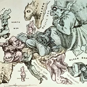
Map of Europe, Napoleon idea 1810

![]()
Wall Art and Photo Gifts from Fine Art Storehouse
Map of Europe, Napoleon idea 1810
Illustration of a map of Europe, Napoleon idea 1810
Unleash your creativity and transform your space into a visual masterpiece!
Nastasic
Media ID 14756710
© This content is subject to copyright
FEATURES IN THESE COLLECTIONS
> Europe
> Related Images
> Fine Art Storehouse
> Map
> Historical Maps
> Maps and Charts
> Early Maps
EDITORS COMMENTS
In this print titled "Map of Europe, Napoleon idea 1810" artist Nastasic takes us on a journey back in time to the early 19th century. The illustration beautifully depicts Napoleon Bonaparte's vision for Europe during his reign as Emperor of the French. The map itself is meticulously detailed, showcasing the vast territories under Napoleon's influence and control. From France at its center, we see an expansive empire stretching across much of Western and Central Europe. Borders are clearly defined, highlighting the strategic importance of each region within Napoleon's grand plan. This artwork not only serves as a historical document but also offers insight into the ambitious aspirations that drove one of history's most iconic figures. It invites us to ponder upon the immense power wielded by Napoleon and his desire to reshape European politics and boundaries according to his own vision. Nastasic's skillful rendering brings life to this historical artifact, allowing viewers to appreciate both its artistic merit and educational value. Whether you're a history enthusiast or simply captivated by cartography, this print is sure to spark curiosity about an era marked by political upheaval and military conquests. "Map of Europe, Napoleon idea 1810" serves as a reminder that art can transcend mere aesthetics; it has the power to transport us through time and ignite our imagination with stories from centuries past.
MADE IN THE USA
Safe Shipping with 30 Day Money Back Guarantee
FREE PERSONALISATION*
We are proud to offer a range of customisation features including Personalised Captions, Color Filters and Picture Zoom Tools
SECURE PAYMENTS
We happily accept a wide range of payment options so you can pay for the things you need in the way that is most convenient for you
* Options may vary by product and licensing agreement. Zoomed Pictures can be adjusted in the Cart.