Home > North America > United States of America > New York > New York > Maps
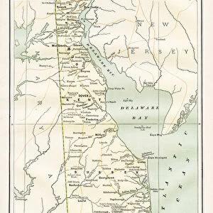
Map of Delaware Maryland Virginia 1894

![]()
Wall Art and Photo Gifts from Fine Art Storehouse
Map of Delaware Maryland Virginia 1894
Johnsons Universal Cyclopedia - Volume VIII New York - A. J. Johnson Company 1894
Unleash your creativity and transform your space into a visual masterpiece!
THEPALMER
Media ID 18356767
FEATURES IN THESE COLLECTIONS
> Fine Art Storehouse
> Map
> Historical Maps
> Maps and Charts
> Early Maps
> North America
> United States of America
> New York
> New York
> Maps
EDITORS COMMENTS
In this print titled "Map of Delaware Maryland Virginia 1894" we are transported back in time to the late 19th century, where cartography was both an art form and a scientific endeavor. The map, sourced from Johnsons Universal Cyclopedia - Volume VIII New York - A. J. Johnson Company in 1894, offers us a glimpse into the intricate details and craftsmanship that went into creating such historical documents. The carefully drawn lines and delicate shading bring forth the geographical features of these three neighboring states: Delaware, Maryland, and Virginia. Each border is meticulously outlined with precision, showcasing the boundaries between these regions during that era. As we explore this vintage map further, our eyes are drawn to the various symbols denoting cities, towns, rivers, mountains, and other significant landmarks scattered across its surface. It serves as a testament to the vast knowledge possessed by early cartographers who dedicated themselves to accurately representing their surroundings for future generations. "The Map of Delaware Maryland Virginia 1894" holds not only historical value but also artistic merit. Its sepia tones evoke a sense of nostalgia while reminding us of an era when maps were cherished possessions used for exploration or planning journeys. This print by THEPALMER captures not just a piece of history but also invites us to appreciate the beauty found within old maps – where science meets artistry – preserving moments frozen in time for all enthusiasts and collectors alike.
MADE IN THE USA
Safe Shipping with 30 Day Money Back Guarantee
FREE PERSONALISATION*
We are proud to offer a range of customisation features including Personalised Captions, Color Filters and Picture Zoom Tools
SECURE PAYMENTS
We happily accept a wide range of payment options so you can pay for the things you need in the way that is most convenient for you
* Options may vary by product and licensing agreement. Zoomed Pictures can be adjusted in the Cart.