Fraud Blocker Skip to main content

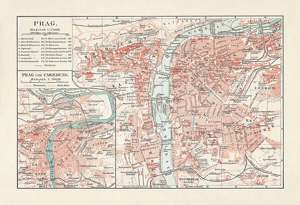
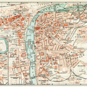
Historical city map of Prague, Czech Republic, lithograph, published 1897

Historical city map of Prague, Czech Republic, lithograph, published 1897
Sold 2
In Stock
We accept all major payment options so you can pay for the things you need in the way that is most convenient for you

Fine Art Storehouse Photo Prints and Wall Art

Historical city map of Prague, Czech Republic, lithograph, published 1897

Historical city map of Prague, capital and largest city of Czech Republic. Lithograph, published in 1897. Unleash your creativity and transform your space into a visual masterpiece.

ZU_09

Media ID 18292255

SECURE PAYMENTS
We accept all major payment options so you can pay for the things you need in the way that is most convenient for you

Made in USA
Safe Shipping, Easy Returns

FREE PERSONALISATION
We are proud to offer a range of customisation including Cropping, Captions, and Filters. Zoom Cropping can be adjusted in the basket


EDITORS COMMENTS

This lithograph takes us on a journey back in time to the enchanting city of Prague, Czech Republic. Published in 1897, this historical city map offers a glimpse into the rich heritage and architectural wonders that have shaped this capital and largest city of the Czech Republic. The intricate details showcased in this print are truly awe-inspiring. Every street, square, and landmark is meticulously illustrated with utmost precision, allowing us to explore Prague's labyrinthine streets as if we were strolling through them ourselves over a century ago. From the iconic Charles Bridge spanning across the Vltava River to the majestic spires of St. Vitus Cathedral at Prague Castle, each element tells its own story. As our eyes wander across this lithograph, we can't help but marvel at how much has changed since its publication. The bustling marketplaces depicted here have transformed into vibrant squares filled with modern-day life; yet somehow, Prague's timeless charm remains intact. Whether you're an avid history enthusiast or simply captivated by the beauty of old-world maps, this stunning print serves as both an exquisite piece of art and a window into Prague's past. It invites us to immerse ourselves in its cultural tapestry and imagine what life was like during that bygone era. Displaying this historical gem proudly on your wall will not only add elegance to any space but also spark conversations about one of Europe's most cherished cities – Prague.


Framed Prints of Historical city map of Prague, Czech Republic, lithograph, published 1897

Step back in time with our exquisite Framed Print of the Historical City Map of Prague, published in 1897. This beautiful lithograph, sourced from the Fine Art Storehouse, showcases the charm and character of Prague, the capital and largest city of the Czech Republic, as it appeared over a century ago. Add a touch of history and timeless elegance to your home or office decor with this captivating piece, perfect for those who appreciate the rich heritage of this enchanting city.


Photo Prints of Historical city map of Prague, Czech Republic, lithograph, published 1897

Step back in time with our exquisite Historical City Map of Prague print from the Media Storehouse Fine Art collection. This stunning lithograph, published in 1897, showcases the enchanting layout of Prague, the capital and largest city of the Czech Republic. With intricate details and beautiful color palette, this historical piece of art transports you to the heart of Europe's ancient beauty. Bring a piece of history into your home or office and add a touch of timeless elegance to your decor. Order now from Media Storehouse and let this unique print tell a story of Prague's rich past.


Poster Prints of Historical city map of Prague, Czech Republic, lithograph, published 1897

"Step back in time with our exquisite Historical City Map of Prague print from the Media Storehouse Fine Art Collection. This stunning lithograph, published in 1897, showcases the enchanting layout of Prague, the capital and largest city of the Czech Republic. With intricate details and beautiful coloring, this piece transports you back to a bygone era. Decorate your home or office with a piece of history and add a touch of timeless charm to your space."


Jigsaw Puzzles of Historical city map of Prague, Czech Republic, lithograph, published 1897

Step back in time with our captivating Historical City Map of Prague jigsaw puzzle from the Media Storehouse range. This intricately detailed puzzle, featuring a lithograph published in 1897, showcases the enchanting cityscape of Prague, the capital and largest city of the Czech Republic. Immerse yourself in the rich history and architectural wonders of this stunning European metropolis as you piece together this beautiful puzzle. A perfect activity for puzzle enthusiasts, history buffs, or anyone seeking a challenging and rewarding experience. Discover the charm of Prague one piece at a time.

diamond
Made With High Grade Materials
thumb_up
Professional Quality Finish
package_2
Carefully Packed To Aid Safe Arrival

You May Also Like


Map of Berlin 1898Map of Berlin 1898
Add to Basket
PraguePrague
Add to Basket
PraguePrague
Add to Basket
Map of Berlin 1895Map of Berlin 1895
Add to Basket
Historical city map of Berlin, Germany, lithograph, published in 1893Historical city map of Berlin, Germany, lithograph, published in 1893
Add to Basket
Postcard, Greetings from HungaryPostcard, Greetings from Hungary
Add to Basket
Central nave of Duomo di Siena (Siena Cathedral) interior, Siena, Tuscany, Italy, EuropeCentral nave of Duomo di Siena (Siena Cathedral) interior, Siena, Tuscany, Italy, Europe
Add to Basket
Map Of Mexiko, 1899Map Of Mexiko, 1899
Add to Basket
Centro Habana Province, Havana, CubaCentro Habana Province, Havana, Cuba
Add to Basket
Norfolk NR1 2 MapNorfolk NR1 2 Map
Add to Basket
Bristol BS16 1 MapBristol BS16 1 Map
Add to Basket
The sea front, Newport, Pembrokeshire, South WalesThe sea front, Newport, Pembrokeshire, South Wales
Add to Basket

Gallery Wall Inspiration

Map Of New Holland
Antique map of Britain under the Anglo Saxons
Battle Of Waterloo
Antique map of the Roman Empire
Map of Cyprus, published in 1880
Map of Middle East - illustration
Earth map according to Herodotus
Antique Map of Norwich, England, 1880
Antique map of Ancient Syria, Mesopotamia, Assyria, Atlas of Ancient Geography
Map of Anglo-Saxon Kingdoms and the Danelaw, 9th Century
Map of North and East sea 1896
Antique map of Britain under the Ancient Romans
Apostle Pauls Missionary Journeys, lithograph, published in 1886
Sicily map 1895
Map of Ireland 1897
Antique map of Tasmania
England in the Ninth Century
Old map of Australia 1899
Ethnological map of the Austro-Hungarian Empire, lithograph, published in 1897
Cornwall map 1884
Antique map of Ireland
Old Caucasus map
Map of Portugal
Carte du Tendre: imaginary map by a character in the novel Cl├®lie
Map of Whitby
Antique map, Scotland, Isle of Skye, South and North Uist
Map of the Byzantine Empire in the 9th Century


© Copyright Media Storehouse, All Rights Reserved 2003 - 2024
Facebook     Pinterest     100% Payment Secure     Reviews IO