Home > Europe > United Kingdom > Scotland > Maps
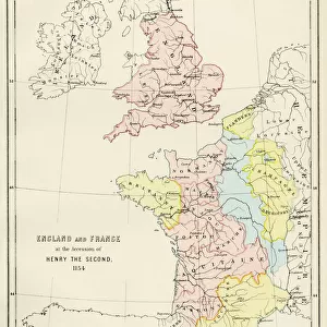
Ancient map of England and France 1881

![]()
Wall Art and Photo Gifts from Fine Art Storehouse
Ancient map of England and France 1881
Encyclopedia Britannica 9th Edition Vol XII Philadelphia j.M. Stoddart & Co 1881
Unleash your creativity and transform your space into a visual masterpiece!
THEPALMER
Media ID 14756292
© This content is subject to copyright
FEATURES IN THESE COLLECTIONS
> Europe
> United Kingdom
> England
> Maps
> Europe
> United Kingdom
> Scotland
> Maps
> Fine Art Storehouse
> Map
> Historical Maps
> Maps and Charts
> Early Maps
EDITORS COMMENTS
In this print titled "Ancient map of England and France 1881" we are transported back in time to an era where cartography was both a science and an art form. This particular piece, sourced from the Encyclopedia Britannica 9th Edition Vol XII published by J. M. Stoddart & Co in Philadelphia in 1881, offers a glimpse into the intricate details of European geography during that period. The map showcases the lands of England and France, two nations with rich histories intertwined through centuries of conquests and conflicts. As our eyes wander across its aged parchment surface, we can almost feel the weight of history upon it. The delicate lines trace borders that have witnessed countless battles, alliances, and territorial shifts over time. With meticulous precision, THEPALMER has captured not only the geographical features but also the essence of these ancient lands. From Scotland's rugged highlands to England's rolling countryside and France's diverse landscapes - each region is depicted with remarkable accuracy. This print serves as a reminder that maps are more than just tools for navigation; they hold stories within their contours. They offer us a window into past civilizations, allowing us to appreciate how boundaries were shaped by human ambition and conflict. As we gaze upon this stunning artwork from Fine Art Storehouse, let us immerse ourselves in its historical significance while marveling at THEPALMER's ability to bring forth such timeless beauty from an age-old document.
MADE IN THE USA
Safe Shipping with 30 Day Money Back Guarantee
FREE PERSONALISATION*
We are proud to offer a range of customisation features including Personalised Captions, Color Filters and Picture Zoom Tools
SECURE PAYMENTS
We happily accept a wide range of payment options so you can pay for the things you need in the way that is most convenient for you
* Options may vary by product and licensing agreement. Zoomed Pictures can be adjusted in the Cart.