Home > Arts > Landscape paintings > Waterfall and river artworks > River artworks
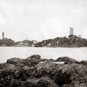
Historical map of the Pearl River Delta, woodcut, published 1897

![]()
Wall Art and Photo Gifts from Fine Art Storehouse
Historical map of the Pearl River Delta, woodcut, published 1897
Historical map of the mouth of the Pearl River Delta (Zhujiang) with the locations of Guangzhou (Canton), Macau and Hong Kong at the end of the 19th century. Wood engraving, published in 1897
Unleash your creativity and transform your space into a visual masterpiece!
Media ID 15309474
© This content is subject to copyright
Bay Of Water British Culture China Chinese Culture Colonialism English Culture Hong Kong Nostalgia Portuguese Culture South China Sea Guangdong Guangzhou Macau Pearl River Zhujiang
FEATURES IN THESE COLLECTIONS
> Arts
> Landscape paintings
> Waterfall and river artworks
> River artworks
> Fine Art Storehouse
> Map
> Historical Maps
> Maps and Charts
> Early Maps
EDITORS COMMENTS
This print takes us back to the end of the 19th century, offering a glimpse into the historical map of the Pearl River Delta. Crafted through woodcut techniques, this exquisite piece showcases an intricate depiction of Guangzhou (Canton), Macau, and Hong Kong - three prominent cities that played significant roles in shaping Chinese and British cultures. The map's vertical orientation allows us to explore every detail with nostalgia. The coastline along the South China Sea unfolds before our eyes, revealing a bay filled with water vessels navigating through its vastness. This visual representation transports us to an era marked by colonialism and trade routes bustling with activity. As we study this remarkable wood engraving, it becomes evident how each city had its distinct character. Guangzhou stands as a testament to Chinese culture, while Macau reflects Portuguese influences due to its history as a former colony. Lastly, Hong Kong emerges as a vibrant hub where British culture seamlessly intertwines with local traditions. This historical artifact not only serves as a valuable resource for understanding Asia's past but also reminds us of the enduring connections between nations across time. Its presence evokes curiosity about how these cities have evolved over centuries while preserving their unique identities within the dynamic landscape of the Pearl River Delta region in Guangdong province
MADE IN THE USA
Safe Shipping with 30 Day Money Back Guarantee
FREE PERSONALISATION*
We are proud to offer a range of customisation features including Personalised Captions, Color Filters and Picture Zoom Tools
SECURE PAYMENTS
We happily accept a wide range of payment options so you can pay for the things you need in the way that is most convenient for you
* Options may vary by product and licensing agreement. Zoomed Pictures can be adjusted in the Cart.