Home > Europe > Denmark > Maps
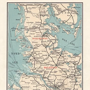
Topographic map of Schleswig-Holstein, German Empire, lithograph, published in 1897

![]()
Wall Art and Photo Gifts from Fine Art Storehouse
Topographic map of Schleswig-Holstein, German Empire, lithograph, published in 1897
Topographic map of Schleswig-Holstein in the German Reich with the former border to Denmark after the German-Danish War (Second Schleswig War) in 1864, existing until 1920. Separate maps of the Kiel Bay and the island of Helgoland. Lithograph, published in 1897
Unleash your creativity and transform your space into a visual masterpiece!
ZU_09
Media ID 18356521
FEATURES IN THESE COLLECTIONS
> Fine Art Storehouse
> Map
> Denmark Maps
> Fine Art Storehouse
> Map
> Historical Maps
> Maps and Charts
> Early Maps
EDITORS COMMENTS
This lithograph, titled "Topographic map of Schleswig-Holstein, German Empire" takes us back to the year 1897. With intricate details and precision, it showcases the region's topography during a significant period in history. The map specifically highlights the former border between Schleswig-Holstein and Denmark after the German-Danish War (Second Schleswig War) that took place in 1864. The viewer is transported to an era when borders were shifting and nations were redefining their territories. This particular print captures a moment frozen in time, as it represents the border that existed until 1920. Notably, this lithograph also includes separate maps of Kiel Bay and Helgoland Island – two prominent landmarks within the region. These additional maps offer a closer look at these specific areas, allowing viewers to explore their geographical features with great detail. As we admire this historical artwork by ZU_09 from Fine Art Storehouse, we are reminded of how cartography has played an essential role throughout human history. It serves as a visual representation of our ever-changing world and provides invaluable insights into past events and landscapes. This lithograph stands as both a testament to human curiosity about our surroundings and an artistic masterpiece capturing a crucial chapter in European history.
MADE IN THE USA
Safe Shipping with 30 Day Money Back Guarantee
FREE PERSONALISATION*
We are proud to offer a range of customisation features including Personalised Captions, Color Filters and Picture Zoom Tools
SECURE PAYMENTS
We happily accept a wide range of payment options so you can pay for the things you need in the way that is most convenient for you
* Options may vary by product and licensing agreement. Zoomed Pictures can be adjusted in the Cart.