Home > North America > United States of America > New York > New York > Maps
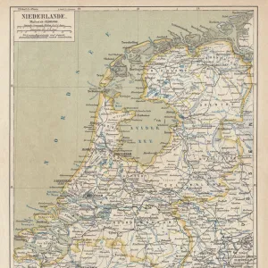
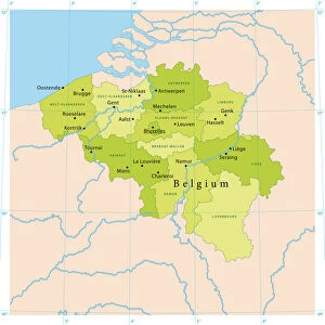
Holland and Belgium map 1875 and Belgium map 1875

![]()
Wall Art and Photo Gifts from Fine Art Storehouse
Holland and Belgium map 1875 and Belgium map 1875
The Independent Course Comprehensive Geography by James Monteith, A.S. Barnes & Co, New York & Chicago 1875
Unleash your creativity and transform your space into a visual masterpiece!
THEPALMER
Media ID 13612207
© This content is subject to copyright
Belgium Globe Navigational Equipment Holland Netherlands Paper Drawing Art Product
FEATURES IN THESE COLLECTIONS
> Europe
> Netherlands
> Maps
> Fine Art Storehouse
> The Magical World of Illustration
> Palmer Illustrated Collection
> Fine Art Storehouse
> Map
> Historical Maps
> Maps and Charts
> Early Maps
> Maps and Charts
> Netherlands
> Maps and Charts
> World
> North America
> United States of America
> Maps
> North America
> United States of America
> New York
> New York
> Maps
EDITORS COMMENTS
This print takes us back in time to the year 1875, showcasing a detailed map of Holland and Belgium. The map is an exquisite piece from "The Independent Course Comprehensive Geography" by James Monteith, published by A. S. Barnes & Co in New York and Chicago during that era. The image transports us to a world where cartography was meticulously crafted through engraving and etching techniques on paper. It showcases the artistry involved in creating maps before the age of digital technology. With its vertical orientation, this antique map offers a glimpse into the physical geography of both countries. Every line, contour, and border has been intricately drawn to provide accurate representation. As we observe this historical artifact, it becomes evident that it serves as more than just navigational equipment; it is also a work of art. The engraved image captures our attention with its fine details and delicate craftsmanship. "The Holland and Belgium Map 1875" invites us to appreciate the rich history embedded within these lands while marveling at the skillful execution of cartographic illustration over a century ago. THEPALMER's expertise in capturing this remarkable print ensures that viewers can relish in its beauty today. This print allows us to cherish not only the historical significance but also THEPALMER's talent for preserving such timeless works for generations to come.
MADE IN THE USA
Safe Shipping with 30 Day Money Back Guarantee
FREE PERSONALISATION*
We are proud to offer a range of customisation features including Personalised Captions, Color Filters and Picture Zoom Tools
SECURE PAYMENTS
We happily accept a wide range of payment options so you can pay for the things you need in the way that is most convenient for you
* Options may vary by product and licensing agreement. Zoomed Pictures can be adjusted in the Cart.