Home > Europe > United Kingdom > Northern Ireland > Maps
UK and Ireland

![]()
Wall Art and Photo Gifts from Fine Art Storehouse
UK and Ireland
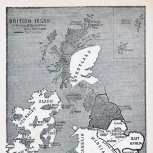
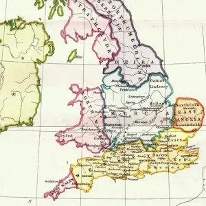
Antique illustration of UK and Ireland
Unleash your creativity and transform your space into a visual masterpiece!
Nastasic
Media ID 13668353
© Nikola Nastasic
1890 1899 66698 78279 Cartographer Equipment Image Created 1890 1899 Memories Navigational Equipment Northern Europe Northern Ireland Nostalgia Republic Of Ireland Styles Ulster Province Image Created 19th Century Obsolete Retro Styled Victorian Style
FEATURES IN THESE COLLECTIONS
> Europe
> Republic of Ireland
> Maps
> Europe
> United Kingdom
> England
> Maps
> Europe
> United Kingdom
> Maps
> Europe
> United Kingdom
> Northern Ireland
> Maps
> Fine Art Storehouse
> The Magical World of Illustration
> Nastasic Images & Illustrations
> Fine Art Storehouse
> Map
> Historical Maps
> Maps and Charts
> Early Maps
> Maps and Charts
> World
EDITORS COMMENTS
This print takes us on a journey back in time to the 19th century, showcasing an antique illustration of the UK and Ireland. With its retro styling and intricate details, this cartographic masterpiece evokes a sense of nostalgia and transports us to a bygone era. The image beautifully captures the Ulster Province, highlighting its historical significance within Northern Ireland. Created by a skilled cartographer using engraved techniques, this Victorian-style illustration showcases the artistry and craftsmanship of that period. As we delve into this color image created between 1890-1899, we are reminded of the rich history and cultural heritage that these lands possess. From England to Northern Ireland, from Scotland to Wales, each region is meticulously depicted with precision and care. This print serves as more than just decorative wall art; it acts as a window into our past. It sparks memories of navigational equipment used during those times when maps were essential tools for exploration and discovery. Let this enchanting piece transport you back in time as you explore the intricacies of old Europe through this remarkable map. Whether you have personal ties to these regions or simply appreciate history's allure, Nastasic's creation offers an opportunity for reflection on how far we've come while honoring the beauty of our shared past.
MADE IN THE USA
Safe Shipping with 30 Day Money Back Guarantee
FREE PERSONALISATION*
We are proud to offer a range of customisation features including Personalised Captions, Color Filters and Picture Zoom Tools
SECURE PAYMENTS
We happily accept a wide range of payment options so you can pay for the things you need in the way that is most convenient for you
* Options may vary by product and licensing agreement. Zoomed Pictures can be adjusted in the Cart.