Home > Arts > Realistic drawings > Pencil drawings > Fine art
Overview map world traffic

![]()
Wall Art and Photo Gifts from Fine Art Storehouse
Overview map world traffic
Unleash your creativity and transform your space into a visual masterpiece!
Nastasic
Media ID 13592325
© Nikola Nastasic
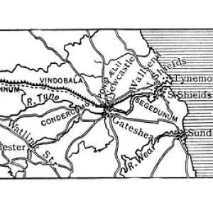
1900 Colors Globe Man Made Object Globe Navigational Equipment Historical Document Pencil Drawing World Map Drawing Art Product
FEATURES IN THESE COLLECTIONS
> Arts
> Realistic drawings
> Pencil drawings
> Fine art
> Fine Art Storehouse
> The Magical World of Illustration
> Nastasic Images & Illustrations
> Fine Art Storehouse
> Map
> Historical Maps
> Maps and Charts
> Early Maps
> Maps and Charts
> World
EDITORS COMMENTS
This print titled "Overview map world traffic" takes us back in time to the year 1900, offering a glimpse into the historical significance of global transportation. The image showcases an antique, engraved map meticulously drawn with pencil and brought to life through vibrant colors. It is a true testament to the artistry and craftsmanship of its creator, Nastasic. The intricate details of this engraving reveal a wealth of information about the world's traffic patterns during that era. From ships navigating vast oceans to trains traversing continents and carriages meandering through bustling cities, every mode of transportation is beautifully depicted on this horizontal map. As we explore this fascinating piece, we are transported across borders and continents, marveling at how man-made objects such as globes and navigational equipment were essential tools for travelers in those times. This illustration serves as both a historical document and an artistic masterpiece that captures the essence of our ever-evolving world. The blend of colors used by Nastasic adds depth and richness to this artwork, enhancing our understanding of global connectivity even further. With each stroke of his pencil, he masterfully brings together history and geography into one harmonious composition. This print from Fine Art Storehouse allows us to appreciate not only the beauty but also the educational value embedded within it. It invites us to reflect on how far we have come in terms of transportation while reminding us that history continues to shape our present-day reality.
MADE IN THE USA
Safe Shipping with 30 Day Money Back Guarantee
FREE PERSONALISATION*
We are proud to offer a range of customisation features including Personalised Captions, Color Filters and Picture Zoom Tools
SECURE PAYMENTS
We happily accept a wide range of payment options so you can pay for the things you need in the way that is most convenient for you
* Options may vary by product and licensing agreement. Zoomed Pictures can be adjusted in the Cart.