Home > Europe > Serbia > Maps
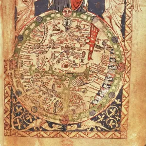
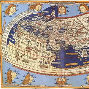
Earth map according to Claudius Ptolemaeus

![]()
Wall Art and Photo Gifts from Fine Art Storehouse
Earth map according to Claudius Ptolemaeus
Antique illustration of a earth map according to Claudius Ptolemaeus
Unleash your creativity and transform your space into a visual masterpiece!
Nastasic
Media ID 13590383
© This content is subject to copyright
Art Product Document Frame Globe Navigational Equipment Land Manuscript Paintings Paper Picture Frame Plan Printout Serbia Social History Topography Wind World Map Claudius Ptolemaeus Claudius Ptolemy Drawing Art Product Painted Image Retro Styled White Color
FEATURES IN THESE COLLECTIONS
> Africa
> Related Images
> Asia
> Related Images
> Fine Art Storehouse
> The Magical World of Illustration
> Nastasic Images & Illustrations
> Fine Art Storehouse
> Map
> Historical Maps
> Maps and Charts
> Early Maps
> Maps and Charts
> World
EDITORS COMMENTS
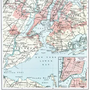
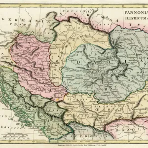
This antique illustration showcases an Earth map according to the renowned Claudius Ptolemaeus. With a retro-styled frame and a horizontal layout, this print takes us back in time, offering a glimpse into the past. The intricate details of Europe, Asia, and Africa are beautifully depicted, with Serbia prominently featured on the map. This artwork transports us to an era when cartography was still in its infancy. The absence of people allows us to focus solely on the historical significance of this document. Painted on old paper using exquisite drawing techniques, it reflects various cultures and their understanding of the world during that period. The wind gracefully sweeps across land and sea as if guiding explorers through uncharted territories. This printout not only serves as a piece of art but also provides valuable insights into social history and physical geography. Its engraved image captures Ptolemy's meticulous topography while showcasing his mastery in cartography. The blue and white color scheme adds depth to this enchanting picture frame, making it an eye-catching addition to any space. Whether displayed in homes or educational institutions, this ancient map sparks curiosity about our planet's past exploration endeavors. Nastasic has expertly preserved history through this engraving-turned-illustration masterpiece. It is truly a testament to Ptolemy's enduring legacy and his contributions to our understanding of the world we inhabit today.
MADE IN THE USA
Safe Shipping with 30 Day Money Back Guarantee
FREE PERSONALISATION*
We are proud to offer a range of customisation features including Personalised Captions, Color Filters and Picture Zoom Tools
SECURE PAYMENTS
We happily accept a wide range of payment options so you can pay for the things you need in the way that is most convenient for you
* Options may vary by product and licensing agreement. Zoomed Pictures can be adjusted in the Cart.