Home > Maps and Charts > Early Maps
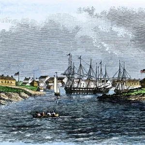
Antique Map of St. Lawrence Area during the War of 1812 - 19th Century

![]()
Wall Art and Photo Gifts from Fine Art Storehouse
Antique Map of St. Lawrence Area during the War of 1812 - 19th Century
Vintage map showing early territorial borders and military positions in the St Lawrence area during the War of 1812. Vintage etching circa late 19th century
Unleash your creativity and transform your space into a visual masterpiece!
powerofforever
Media ID 15149725
© This content is subject to copyright
Territory War Of 1812 Ogdensburg Plattsburg
FEATURES IN THESE COLLECTIONS
> Fine Art Storehouse
> History
> Battles & Wars
> Historcal Battle Maps and Plans
> Fine Art Storehouse
> Map
> Historical Maps
> Maps and Charts
> Early Maps
EDITORS COMMENTS
This vintage etching takes us back to the early 19th century, providing a glimpse into the territorial borders and military positions in the St. Lawrence area during the War of 1812. The antique map showcases intricate details and historical significance, making it a valuable piece for history enthusiasts. The map highlights key locations such as Ogdensburg, Battle of Sackets Harbor, Sackets Harbor itself, and Plattsburg. These places played crucial roles in shaping the outcome of this significant conflict between British forces and American troops. As we study this print closely, we can almost imagine ourselves transported to that era, witnessing the strategic movements and battles that took place along these territories. It serves as a visual reminder of how boundaries were contested and redrawn during times of war. Preserved through time with its aged charm intact, this antique map offers an opportunity to explore our past from a different perspective. Its presence on any wall or display would undoubtedly spark conversations about history's impact on our present-day world. Powerofforever has skillfully captured not only geographical accuracy but also the essence of an era long gone by presenting us with this remarkable piece of artistry. Whether you are a collector or simply appreciate historical artifacts, this print is sure to captivate your imagination while honoring those who fought bravely during one of America's defining conflicts - The War of 1812.
MADE IN THE USA
Safe Shipping with 30 Day Money Back Guarantee
FREE PERSONALISATION*
We are proud to offer a range of customisation features including Personalised Captions, Color Filters and Picture Zoom Tools
SECURE PAYMENTS
We happily accept a wide range of payment options so you can pay for the things you need in the way that is most convenient for you
* Options may vary by product and licensing agreement. Zoomed Pictures can be adjusted in the Cart.