Home > Europe > United Kingdom > Scotland > Maps
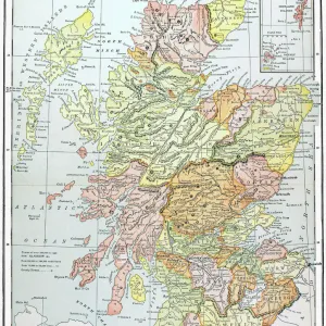
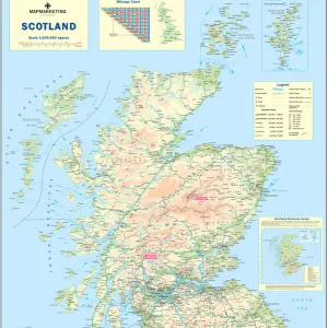
Antique damaged map of Scotland in the 19th Century

![]()
Wall Art and Photo Gifts from Fine Art Storehouse
Antique damaged map of Scotland in the 19th Century
Vintage engraving of a Antique damaged map of Scotland in the 19th Century, 1873
Unleash your creativity and transform your space into a visual masterpiece!
duncan1890
Media ID 13609237
© This content is subject to copyright
1870 1879 Bad Condition Colour Colours Condition Damaged Equipment Faded Great Britain Highland Image Created 1870 1879 Navigational Equipment Northern Europe Retro Scotland Scottish Highlands Styles Supplies United Kingdom Victorian Highlands Region Retro Styled Shetland Islands Victorian Style
FEATURES IN THESE COLLECTIONS
> Europe
> United Kingdom
> Maps
> Europe
> United Kingdom
> Paintings
> Europe
> United Kingdom
> Scotland
> Highlands
> Related Images
> Europe
> United Kingdom
> Scotland
> Maps
> Europe
> United Kingdom
> Scotland
> Paintings
> Fine Art Storehouse
> Map
> Historical Maps
> Maps and Charts
> Early Maps
EDITORS COMMENTS
This print showcases an antique damaged map of Scotland from the 19th century. The vintage engraving, created in 1873, exudes a sense of history and nostalgia. Despite its bad condition, the map still retains its charm and allure. The image depicts a faded and worn-out map that provides a glimpse into the past. Its intricate details highlight various regions within Scotland, including the famous Scottish Highlands and Shetland Islands. This piece of cartography serves as a testament to the navigational equipment used during that era. The Victorian style illustration transports viewers back in time, evoking feelings of curiosity about how people perceived geography in those days. The use of vibrant colors adds depth to this old-fashioned artwork while simultaneously reflecting the artistic styles prevalent during that period. As an archival photograph, it preserves not only historical information but also cultural significance. It reminds us of our connection to the United Kingdom's rich heritage and offers insights into European history as well. With its vertical composition and retro-styled aesthetics, this print is perfect for enthusiasts who appreciate vintage art or have an interest in Scottish culture. Duncan1890 has masterfully captured this timeless piece with utmost care and attention to detail, making it a valuable addition to any collection or decor scheme.
MADE IN THE USA
Safe Shipping with 30 Day Money Back Guarantee
FREE PERSONALISATION*
We are proud to offer a range of customisation features including Personalised Captions, Color Filters and Picture Zoom Tools
SECURE PAYMENTS
We happily accept a wide range of payment options so you can pay for the things you need in the way that is most convenient for you
* Options may vary by product and licensing agreement. Zoomed Pictures can be adjusted in the Cart.