Home > Europe > United Kingdom > England > Durham > Sunderland
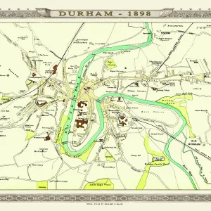
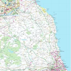
Map of the City of Durham, England Victorian Engraving, 1840

![]()
Wall Art and Photo Gifts from Fine Art Storehouse
Map of the City of Durham, England Victorian Engraving, 1840
Very Rare, Beautifully Illustrated Antique Engraving of Map of the City of Durham, England Victorian Engraving, 1840. Source: Original edition from my own archives. Copyright has expired on this artwork. Digitally restored
Unleash your creativity and transform your space into a visual masterpiece!
bauhaus1000
Media ID 13667301
© This content is subject to copyright
1800s Art Product British Culture Chart County Durham Diagram Direction Graph Great Britain Newcastle Upon Tyne Non Us Location Plan Residential District River Wear Sunderland Thoroughfare Village Drawing Art Product Victorian Style
FEATURES IN THESE COLLECTIONS
> Arts
> Landscape paintings
> Waterfall and river artworks
> River artworks
> Arts
> Portraits
> Pop art gallery
> Street art portraits
> Europe
> United Kingdom
> England
> County Durham
> Durham
> Europe
> United Kingdom
> England
> Durham
> Durham
> Europe
> United Kingdom
> England
> Durham
> Sunderland
> Europe
> United Kingdom
> England
> Maps
> Europe
> United Kingdom
> England
> Newcastle upon Tyne
> Europe
> United Kingdom
> England
> Rivers
> Europe
> United Kingdom
> England
> Sunderland
> Europe
> United Kingdom
> Maps
> Fine Art Storehouse
> Map
> Historical Maps
EDITORS COMMENTS
This beautifully illustrated antique engraving of the Map of the City of Durham, England takes us back to the Victorian era in 1840. A rare find from my own archives, this print captures the essence and charm of a bygone era. The intricate details and craftsmanship showcased in this artwork are truly remarkable. The map showcases the city's layout with precision, highlighting its famous landmarks such as the River Wear and various thoroughfares. It offers a glimpse into British culture during that time, depicting both residential districts and bustling town centers. The Victorian style adds an air of elegance to this historical piece. Digitally restored to its former glory, this print allows us to appreciate not only its artistic value but also its significance in cartography and history. As we examine every line and curve on this map, we can't help but feel transported back in time. Whether you're a history enthusiast or simply captivated by art from the 19th century, this Map of Durham is sure to be a cherished addition to any collection. Its timeless appeal transcends borders as it appeals not only to those familiar with Great Britain but also attracts interest from across continents like USA.
MADE IN THE USA
Safe Shipping with 30 Day Money Back Guarantee
FREE PERSONALISATION*
We are proud to offer a range of customisation features including Personalised Captions, Color Filters and Picture Zoom Tools
SECURE PAYMENTS
We happily accept a wide range of payment options so you can pay for the things you need in the way that is most convenient for you
* Options may vary by product and licensing agreement. Zoomed Pictures can be adjusted in the Cart.