Home > Arts > Artists > B > John Warner Barber
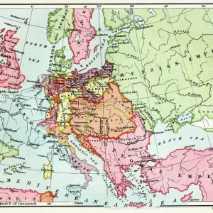
Map of the United States in 1803, from Our Whole Country: The Past and Present

![]()
Wall Art and Photo Gifts from Fine Art Finder
Map of the United States in 1803, from Our Whole Country: The Past and Present
BAL124927 Map of the United States in 1803, from Our Whole Country: The Past and Present of the United States, Historical and Descriptive, by John Warner Barber and Henry Hare, 1861 (engraving) by American School, (19th century); Private Collection; American, out of copyright
Media ID 12717803
© www.bridgemanimages.com
Frontier North State Undiscovered
FEATURES IN THESE COLLECTIONS
> Arts
> Artists
> B
> John Warner Barber
> Arts
> Artists
> M
> Mexican School Mexican School
> Fine Art Finder
> Schools
> American School
> Maps and Charts
> Early Maps
> Maps and Charts
> Related Images
> North America
> Canada
> Maps
> North America
> Canada
> Related Images
> North America
> Mexico
> Maps
> North America
> Mexico
> Related Images
EDITORS COMMENTS
This print showcases a remarkable piece of history - the Map of the United States in 1803. Taken from the renowned book "Our Whole Country: The Past and Present of the United States" this engraving by John Warner Barber and Henry Hare in 1861 offers a glimpse into America's past. The map depicts an era when the United States was still expanding, with vast uncharted territories waiting to be explored. It captures the spirit of adventure and discovery that defined this period, as explorers ventured into unknown lands, pushing boundaries beyond what was previously imagined. From east to west, one can trace the frontier settlements gradually giving way to untamed wilderness. The borders extend southward towards Mexico and northwards towards Canada, reminding us that even then, America had connections with its neighboring countries. This print not only serves as a visual representation but also invites contemplation about how far our nation has come since those early days. It reminds us of our rich heritage and diverse landscapes that have shaped American culture throughout centuries. As we gaze upon this image, we are transported back in time - witnessing a moment frozen forever on paper. It is a testament to both human curiosity and resilience; an ode to exploration and growth that continues to define North America today.
MADE IN THE USA
Safe Shipping with 30 Day Money Back Guarantee
FREE PERSONALISATION*
We are proud to offer a range of customisation features including Personalised Captions, Color Filters and Picture Zoom Tools
SECURE PAYMENTS
We happily accept a wide range of payment options so you can pay for the things you need in the way that is most convenient for you
* Options may vary by product and licensing agreement. Zoomed Pictures can be adjusted in the Cart.