Home > Asia > Kazakhstan > Kazakhstan Heritage Sites > Silk Roads: the Routes Network of
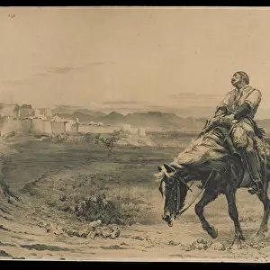
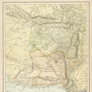
Map of Central Asia, 1834 (colour litho)
")
![]()
Wall Art and Photo Gifts from Fine Art Finder
Map of Central Asia, 1834 (colour litho)
XCF282016 Map of Central Asia, 1834 (colour litho) by Arrowsmith, John (1790-1873); Private Collection; English, out of copyright
Media ID 12795142
© www.bridgemanimages.com
Afghanistan Boundaries Bukhara Frontier Iran Kazakhstan Kyrgyzstan Mapping Pakistan Silk Road Silk Route Turkmenistan Uzbekistan Middle Asia River Indus
FEATURES IN THESE COLLECTIONS
> Fine Art Finder
> Artists
> John Arrowsmith
> Arts
> Artists
> A
> John Arrowsmith
> Arts
> Landscape paintings
> Waterfall and river artworks
> River artworks
> Asia
> Afghanistan
> Maps
> Asia
> Afghanistan
> Related Images
> Asia
> Iran
> Related Images
> Asia
> Kazakhstan
> Kazakhstan Heritage Sites
> Silk Roads: the Routes Network of
> Asia
> Kazakhstan
> Maps
> Asia
> Kazakhstan
> Related Images
> Asia
> Kyrgyzstan
> Maps
EDITORS COMMENTS
This print showcases a remarkable piece of cartographic history - the "Map of Central Asia, 1834" by John Arrowsmith. With its vibrant colors and intricate details, this lithograph takes us back to a time when exploration and discovery were at their peak. The map encompasses an extensive region, stretching from Uzbekistan to Pakistan, Afghanistan to Iran, Turkmenistan to Tajikstan. It highlights the ancient Silk Road or Silk Route that connected these lands for centuries. The boundaries of various empires are clearly marked, giving us insight into the geopolitical landscape of the time. As we gaze upon this masterpiece, we can't help but marvel at how it encapsulates the rich cultural heritage and historical significance of Central Asia. From Bukhara's grandeur to the mighty River Indus flowing through Pakistan's fertile plains, every detail tells a story. This image serves as a window into Middle Asia or Inner Asia during the 19th century. It reminds us of the vastness and diversity that characterizes this part of our world - from Kazakhstan's expansive steppes to Kyrgyzstan's majestic mountains. With its meticulous craftsmanship and wealth of information, this map is not only an invaluable resource for geographers but also a visual delight for anyone with an appreciation for art and history. Let it transport you back in time as you explore the borders and frontiers that shaped Central Asia's past.
MADE IN THE USA
Safe Shipping with 30 Day Money Back Guarantee
FREE PERSONALISATION*
We are proud to offer a range of customisation features including Personalised Captions, Color Filters and Picture Zoom Tools
SECURE PAYMENTS
We happily accept a wide range of payment options so you can pay for the things you need in the way that is most convenient for you
* Options may vary by product and licensing agreement. Zoomed Pictures can be adjusted in the Cart.