Home > Asia > China > Maps
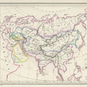
Map of Asia at the time of the greatest extent of the domination of the Mongols in
![]()

Wall Art and Photo Gifts from Fine Art Finder
Map of Asia at the time of the greatest extent of the domination of the Mongols in
KW2603386 Map of Asia at the time of the greatest extent of the domination of the Mongols in the reign of Kublai Khan, from L Histoire Universelle Ancienne et Moderne, published in Strasbourg c.1860 (coloured engraving) by French School, (19th century); Private Collection; (add.info.: Kublai Khan (September 23, 1215 a February 18, 1294), also known as Shizu, fifth Khagan of the Mongol Empire, reigned from 1260 to 1294 and founded the Yuan dynasty in China in 1271, a division of the Mongol Empire.); Ken Welsh; French, out of copyright
Media ID 12775863
© www.bridgemanimages.com
Chart Charts Conquest Expansion Kublai Khan Mongol Empire Territory Yuan Dynasty Great Khan Khagan
FEATURES IN THESE COLLECTIONS
> Fine Art Finder
> Maps (celestial & Terrestrial)
> Fine Art Finder
> Schools
> French School
> Maps and Charts
> Related Images
EDITORS COMMENTS
This print showcases a Map of Asia during the height of Mongol domination under the reign of Kublai Khan. Published in Strasbourg around 1860, this colored engraving provides a glimpse into the vast territories controlled by the Mongols during their expansionist era. Kublai Khan, also known as Shizu, was the fifth Khagan of the Mongol Empire and ruled from 1260 to 1294. His influence extended far beyond Mongolia, as he founded China's Yuan dynasty in 1271. This division marked a significant chapter in Asian history and solidified Mongol control over an extensive portion of Asia. The map itself is intricately detailed, highlighting various regions and territories conquered by the Mongols. It serves as a visual testament to their military prowess and ambition for territorial expansion. The chart not only depicts political boundaries but also offers insights into trade routes and cultural exchanges that flourished under Mongol rule. Preserved within a private collection, this historical artifact sheds light on one of history's most influential empires. Its inclusion in L'Histoire Universelle Ancienne et Moderne further emphasizes its significance as an enduring symbol of power and conquest. As we gaze upon this remarkable piece, we are reminded of Kublai Khan's legacy - his ability to unite diverse lands under one empire while leaving an indelible mark on Asian history.
MADE IN THE USA
Safe Shipping with 30 Day Money Back Guarantee
FREE PERSONALISATION*
We are proud to offer a range of customisation features including Personalised Captions, Color Filters and Picture Zoom Tools
SECURE PAYMENTS
We happily accept a wide range of payment options so you can pay for the things you need in the way that is most convenient for you
* Options may vary by product and licensing agreement. Zoomed Pictures can be adjusted in the Cart.


