Home > Arts > Artists > B > Charles Marie Rigobert Bonne
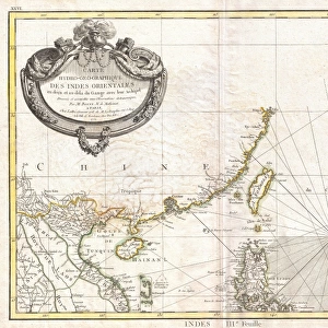
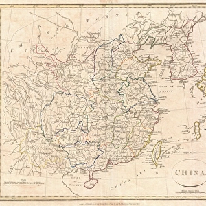
The Chinese Empire, Chinese Tartary and the Kingdom of Korea, with the Islands of Japan

![]()
Wall Art and Photo Gifts from Fine Art Finder
The Chinese Empire, Chinese Tartary and the Kingdom of Korea, with the Islands of Japan
KW206604 The Chinese Empire, Chinese Tartary and the Kingdom of Korea, with the Islands of Japan, from Atlas de Toutes les Parties Connues du Globe Terrestre by Guillaume Raynal (1713-96) published 1780 (coloured engraving) by Bonne, Charles Marie Rigobert (1727-95); Private Collection; Ken Welsh; French, out of copyright
Media ID 12755743
© www.bridgemanimages.com
FEATURES IN THESE COLLECTIONS
> Arts
> Artists
> B
> Charles Marie Rigobert Bonne
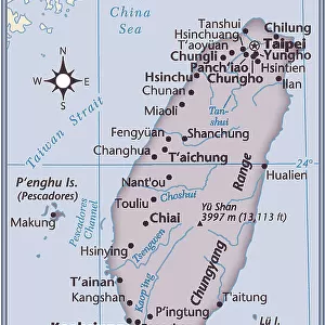
> Asia
> Japan
> Related Images
> Asia
> Related Images
> Asia
> Taiwan
> Related Images
> Fine Art Finder
> Artists
> Charles Marie Rigobert Bonne
EDITORS COMMENTS
This print, titled "The Chinese Empire, Chinese Tartary and the Kingdom of Korea, with the Islands of Japan" takes us on a visual journey through the vast lands of East Asia. Created by Guillaume Raynal in 1780 and beautifully engraved by Charles Marie Rigobert Bonne, this coloured engraving offers a glimpse into the intricate cartography of its time. The map showcases the expansive territories that once constituted the mighty Chinese Empire, stretching from China proper to Chinese Tartary and encompassing the Kingdom of Korea. The inclusion of Japan's islands further enriches this historical snapshot. With meticulous detail and vibrant colors, this print not only serves as a geographical reference but also provides insight into cultural connections between these nations. It invites contemplation on how trade routes were established across land and sea during this era. As we admire this piece from our private collection today, it reminds us of the importance placed on exploration and knowledge-sharing throughout history. It is a testament to human curiosity and our innate desire to understand distant lands. This remarkable artwork allows us to appreciate both its aesthetic appeal as well as its historical significance. It serves as a reminder that art can be an invaluable tool for preserving our collective memory while offering endless opportunities for discovery.
MADE IN THE USA
Safe Shipping with 30 Day Money Back Guarantee
FREE PERSONALISATION*
We are proud to offer a range of customisation features including Personalised Captions, Color Filters and Picture Zoom Tools
SECURE PAYMENTS
We happily accept a wide range of payment options so you can pay for the things you need in the way that is most convenient for you
* Options may vary by product and licensing agreement. Zoomed Pictures can be adjusted in the Cart.