Home > Europe > Denmark > Odense
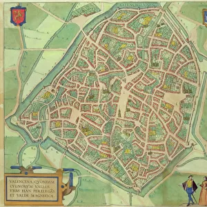
Map of Odense, from Civitates Orbis Terrarum by Georg Braun (1541-1622

![]()
Wall Art and Photo Gifts from Fine Art Finder
Map of Odense, from Civitates Orbis Terrarum by Georg Braun (1541-1622
STC138948 Map of Odense, from Civitates Orbis Terrarum by Georg Braun (1541-1622) and Frans Hogenberg (1535-90) 1597 (coloured engraving) by Hoefnagel, Joris (1542-1600) (after); Private Collection; The Stapleton Collection; Flemish, out of copyright
Media ID 23255670
© The Stapleton Collection / Bridgeman Images
Atlas Birds Eye View Canute Cities Of The World Danish Denmark
FEATURES IN THESE COLLECTIONS
> Arts
> Artists
> H
> Joris Hoefnagel
> Europe
> Denmark
> Related Images
> Fine Art Finder
> Artists
> Joris (after) Hoefnagel
> Fine Art Finder
> Maps (celestial & Terrestrial)
> Maps and Charts
> Related Images
> Maps and Charts
> World
EDITORS COMMENTS
This print showcases a remarkable piece of cartographic history - the Map of Odense. Created by Georg Braun and Frans Hogenberg in 1597, this coloured engraving offers a fascinating glimpse into the city's landscape during the 16th century. The intricate details and exquisite artistry make it an invaluable addition to any collection. Odense, known as "Odins Island" in ancient times, is beautifully depicted with its charming streets, majestic St Canutes Cathedral, and the picturesque Odense Fjord. This birds-eye view allows us to immerse ourselves in the rich history and architectural wonders that once graced this Danish city. As we explore every corner of this map, we are transported back in time to an era when canals were bustling with activity and trade routes connected cities across the world. The attention to detail is truly awe-inspiring; from meticulously drawn buildings to ships sailing on the fjord, each element tells a story of Odense's past. The Map of Odense not only serves as a visual representation but also acts as a portal through which we can discover how civilizations have evolved over centuries. It reminds us that beneath our modern landscapes lie layers upon layers of history waiting to be unveiled. This print from Fine Art Finder captures every nuance and hue with utmost precision, allowing viewers to appreciate Joris Hoefnagel's masterful reproduction of Braun and Hogenberg's original work. Whether you are an avid collector or simply intrigued by
MADE IN THE USA
Safe Shipping with 30 Day Money Back Guarantee
FREE PERSONALISATION*
We are proud to offer a range of customisation features including Personalised Captions, Color Filters and Picture Zoom Tools
SECURE PAYMENTS
We happily accept a wide range of payment options so you can pay for the things you need in the way that is most convenient for you
* Options may vary by product and licensing agreement. Zoomed Pictures can be adjusted in the Cart.