Home > Arts > Artists > B > Joan Blaeu
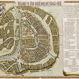
Map of China, from Atlas Maior Sive Cosmographia Blaviana

![]()
Wall Art and Photo Gifts from Fine Art Finder
Map of China, from Atlas Maior Sive Cosmographia Blaviana
986216 Map of China, from Atlas Maior Sive Cosmographia Blaviana, 1662 (hand-coloured engraving) by Blaeu, Joan (1596-1673); Private Collection; (add.info.: Map of China, from Atlas Maior Sive Cosmographia Blaviana... by Joan Blaeu (1596-1673). Hand-coloured engraving. Published, 1662. This map comes from what has been called the greatest and finest atlas ever published.); Photo eChristies Images; Dutch, out of copyright
Media ID 22201954
© Christie's Images / Bridgeman Images
1660s 1662 Artist Dutch Atlas Blaeu Capital Letter Cartography Cosmography Dutch Art Dutch Artist Engraved Geographic Hand Colored Hand Coloring Hand Coloured Hand Colouring Hand Tinted Handcolored Joan Blaeu Johannes Language Late 17th Century Late Seventeenth Century Navigational Equipment Netherlandish Artist Prints Handcoloured Johannes Blaeu Johannes Willemszoon Blaeu
FEATURES IN THESE COLLECTIONS
> Arts
> Artists
> B
> Joan Blaeu
> Fine Art Finder
> Artists
> Joan Blaeu
> Fine Art Finder
> Temp Classification
EDITORS COMMENTS
This print showcases a close-up of the "Map of China" from the renowned Atlas Maior Sive Cosmographia Blaviana, created by Dutch cartographer Joan Blaeu in 1662. Hand-coloured and engraved with meticulous detail, this map is considered one of the greatest and finest atlases ever published. The intricate craftsmanship is evident in every aspect of this artwork. The vibrant hand colouring brings to life the geographical features and navigational equipment depicted on the map. As we explore closer, we can appreciate the skillful execution of each line and stroke that forms an accurate representation of China during the late seventeenth century. The absence of any human presence allows us to focus solely on the beauty and precision of this piece. The capital letters scattered across the map provide additional context and information about various regions within China. Through this photograph, we are transported back in time to an era when cartography was both a scientific pursuit and an artistic endeavor. It serves as a testament to Johannes Blaeu's mastery as a Netherlandish artist, capturing not only geographic accuracy but also evoking a sense of wonder for distant lands. This print offers viewers a glimpse into history while highlighting Europe's fascination with Asia during the seventeenth century. Its rich colors, detailed engravings, and exquisite hand coloring make it an exceptional addition to any collection or display dedicated to antique maps or Dutch art.
MADE IN THE USA
Safe Shipping with 30 Day Money Back Guarantee
FREE PERSONALISATION*
We are proud to offer a range of customisation features including Personalised Captions, Color Filters and Picture Zoom Tools
SECURE PAYMENTS
We happily accept a wide range of payment options so you can pay for the things you need in the way that is most convenient for you
* Options may vary by product and licensing agreement. Zoomed Pictures can be adjusted in the Cart.