Home > Arts > Artists > O > Abraham Ortelius
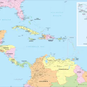
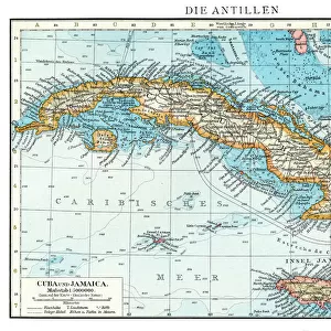
Map of the Caribbean Sea by Christophe Plantin, 1588

![]()
Wall Art and Photo Gifts from Fine Art Finder
Map of the Caribbean Sea by Christophe Plantin, 1588
AIS5350385 Map of the Caribbean Sea by Christophe Plantin, 1588 by Plantin, Christophe (1414 or 1420-1589); Biblioteca Universidad, Salamanca, Spain; (add.info.: Map of the Caribbean Sea with the islands of Cuba, Caiman, Jamaica and Florida. Etching in colors, 1588, by Christophe Plantin (1414 or 1420-1589), in Theatrum Orbis Terrarum by Abraham Ortelius (1527-1598). University Library of Salamanca (Spain).); © Iberfoto
Media ID 25215388
© Iberfoto / Bridgeman Images
Atlas Book Of Maps Caribbean Carribean Central America City Map City Plan Cuba Cuba Cuban Cuban Cubans Etching General Map Geographical Map Jamaica Jamaica Jamaican Jamaican Jamaicans Street Plan America Continent
FEATURES IN THESE COLLECTIONS
> Arts
> Artists
> O
> Abraham Ortelius
> Fine Art Finder
> Artists
> Christophe Plantin
> Fine Art Finder
> Artists
> Henri de Toulouse-Lautrec
> Maps and Charts
> Abraham Ortelius
> Maps and Charts
> Spain
> North America
> Cuba
> Maps
> North America
> Cuba
> Related Images
> North America
> Jamaica
> Maps
> North America
> Jamaica
> Related Images
EDITORS COMMENTS
This print showcases the "Map of the Caribbean Sea" created by Christophe Plantin in 1588. The intricate etching in colors depicts a detailed cartographic representation of the Caribbean region, including notable islands such as Cuba, Caiman, Jamaica, and Florida. This historical masterpiece was featured in "Theatrum Orbis Terrarum" an atlas book of maps compiled by Abraham Ortelius. Plantin's map provides a fascinating glimpse into the geographical landscape of the Western Hemisphere during the 16th century. It serves as a testament to his exceptional skills as a cartographer and his dedication to accurately representing this part of America continent. The vibrant colors used in this etching bring life to each island and highlight their unique characteristics. As you explore this map, you can almost imagine sailing through these turquoise waters and discovering new lands. Preserved within Biblioteca Universidad in Salamanca, Spain, this invaluable piece offers insights into early European exploration and colonization efforts across Central America. Its significance lies not only in its artistic beauty but also its contribution to our understanding of historical geography. Bridgeman Images has expertly captured every detail of this remarkable artwork for all enthusiasts to appreciate. Whether you are interested in general maps or have a specific fascination with Caribbean history, this print is sure to captivate your imagination and transport you back centuries ago when these islands were still being explored.
MADE IN THE USA
Safe Shipping with 30 Day Money Back Guarantee
FREE PERSONALISATION*
We are proud to offer a range of customisation features including Personalised Captions, Color Filters and Picture Zoom Tools
SECURE PAYMENTS
We happily accept a wide range of payment options so you can pay for the things you need in the way that is most convenient for you
* Options may vary by product and licensing agreement. Zoomed Pictures can be adjusted in the Cart.