Home > Arts > Artists > G > Giovanni Xenodocus da Corfu
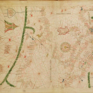
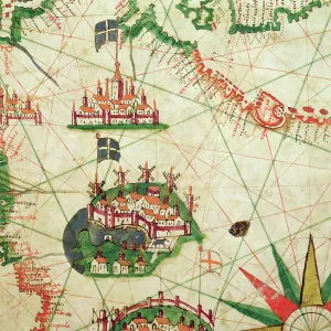
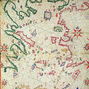
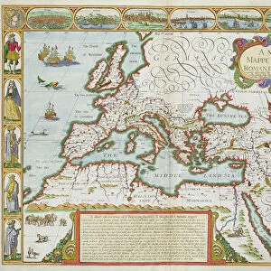
Provence and Northern Italy, from a nautical atlas, 1520 (ink on vellum)
")
![]()
Wall Art and Photo Gifts from Fine Art Finder
Provence and Northern Italy, from a nautical atlas, 1520 (ink on vellum)
XOT330917 Provence and Northern Italy, from a nautical atlas, 1520 (ink on vellum) by Giovanni Xenodocus da Corfu (fl. 16th Century); Museo Correr, Venice, Italy; Greek, out of copyright
Media ID 18255145
© Museo Correr, Venice, Italy / Bridgeman Images
Cartography Chart Cities Genoa Mapping Mediterranean Sea Portolan
FEATURES IN THESE COLLECTIONS
> Arts
> Artists
> G
> Giovanni Xenodocus da Corfu
> Europe
> Italy
> Liguria
> Genoa
> Europe
> Italy
> Veneto
> Venice
> Fine Art Finder
> Artists
> G
> Giovanni Xenodocus da Corfu Giovanni
> Fine Art Finder
> Artists
> Giovanni Xenodocus da Corfu
> Maps and Charts
> Italy
EDITORS COMMENTS
This print showcases a remarkable piece of cartographic history, "Provence and Northern Italy" taken from a nautical atlas dating back to 1520. Created by the skilled hand of Giovanni Xenodocus da Corfu, a prominent figure in the 16th century, this ink on vellum masterpiece is now housed in the prestigious Museo Correr in Venice, Italy. The intricate details and precision evident in this map transport us back to an era when exploration and navigation were at their peak. The artist's expertise shines through as he meticulously captures the cities and ports that dot the Mediterranean Sea. From Genoa to Marseille, each location is carefully marked with accuracy and finesse. As we gaze upon this historical artifact, we are reminded of the importance of maps during this time period. Serving as vital tools for sailors and merchants alike, these charts played a crucial role in guiding ships safely across treacherous waters while facilitating trade between nations. With its rich colors and delicate lines etched onto vellum, this print not only offers us a glimpse into past maritime adventures but also serves as a testament to the artistry involved in early cartography. It stands as both an educational resource for understanding our world's history and a visually stunning work of art that can be appreciated by all who encounter it.
MADE IN THE USA
Safe Shipping with 30 Day Money Back Guarantee
FREE PERSONALISATION*
We are proud to offer a range of customisation features including Personalised Captions, Color Filters and Picture Zoom Tools
SECURE PAYMENTS
We happily accept a wide range of payment options so you can pay for the things you need in the way that is most convenient for you
* Options may vary by product and licensing agreement. Zoomed Pictures can be adjusted in the Cart.