Home > Arts > Artists > G > Giovanni Xenodocus da Corfu
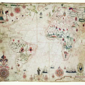
The Eastern Mediterranean, from a nautical atlas, 1520 (ink on vellum) (see also 330914)
 (see also 330914)")
![]()
Wall Art and Photo Gifts from Fine Art Finder
The Eastern Mediterranean, from a nautical atlas, 1520 (ink on vellum) (see also 330914)
XOT330913 The Eastern Mediterranean, from a nautical atlas, 1520 (ink on vellum) (see also 330914) by Giovanni Xenodocus da Corfu (fl. 16th Century); 32x22.3 cm; Museo Correr, Venice, Italy; Greek, out of copyright
Media ID 12852569
© www.bridgemanart.com
Aegean Sea Anatolia Black Sea Chart Crete Cyprus Encampment Greek Islands Mapping Portolan Red Sea Tents
FEATURES IN THESE COLLECTIONS
> Arts
> Artists
> G
> Giovanni Xenodocus da Corfu
> Asia
> Cyprus
> Related Images
> Asia
> Turkey
> Related Images
> Europe
> Greece
> Related Images
> Europe
> Italy
> Veneto
> Venice
> Fine Art Finder
> Artists
> G
> Giovanni Xenodocus da Corfu Giovanni
> Fine Art Finder
> Artists
> Giovanni Xenodocus da Corfu
> Historic
> Ancient civilizations
> Ancient Greece
> Greek history
EDITORS COMMENTS
This print showcases "The Eastern Mediterranean" as depicted in a nautical atlas from 1520. Created by the skilled hand of Giovanni Xenodocus da Corfu, this ink on vellum masterpiece measures 32x22.3 cm and is currently housed in the Museo Correr in Venice, Italy. The image transports us to a time when cartography was still a burgeoning field, and sailors relied on detailed charts like this one to navigate treacherous waters. The map encompasses an expansive region, spanning from Turkey and Greece to the Greek Islands and beyond. It includes notable landmarks such as the Aegean Sea, Crete, Cyprus, Cilician Sea, Anatolia, Red Sea, Black Sea, and parts of the Middle East. Intriguingly enough, amidst this vast expanse of water lies an encampment with several tents pitched along its shores. This inclusion adds a touch of human presence against nature's grandeur—a reminder that even in uncharted territories there were those who sought shelter and sustenance. "The Eastern Mediterranean" serves not only as a historical document but also as a testament to the artistry involved in early cartography. Its intricate details invite viewers to delve into its depths while appreciating both its aesthetic beauty and practical significance. Through this print provided by Fine Art Finder via www. bridgemanart. com we are granted access to an ancient world where exploration met creativity—an era when maps were more than just navigational tools
MADE IN THE USA
Safe Shipping with 30 Day Money Back Guarantee
FREE PERSONALISATION*
We are proud to offer a range of customisation features including Personalised Captions, Color Filters and Picture Zoom Tools
SECURE PAYMENTS
We happily accept a wide range of payment options so you can pay for the things you need in the way that is most convenient for you
* Options may vary by product and licensing agreement. Zoomed Pictures can be adjusted in the Cart.