Home > Europe > France > Heritage Sites > Routes of Santiago de Compostela in
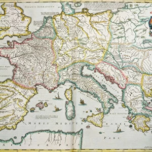
Reproduction of Map of Routes of St. James of Compostel, originally engraved by D

![]()
Wall Art and Photo Gifts from Fine Art Finder
Reproduction of Map of Routes of St. James of Compostel, originally engraved by D
CHT179600 Reproduction of Map of Routes of St. James of Compostel, originally engraved by D.Serveaux 1648 by French School, (17th century) (after); Private Collection; (add.info.: Carte des Chemins de Saint Jacques de Compostelle; list of French sanctuaries for pilgrims; ); eArchives Charmet; French, out of copyright
Media ID 23355554
© Archives Charmet / Bridgeman Images
Badge Jacquet Pilgrim Pilgrimage Pilgrims Pilgrims Staff Scallop Shell Camino Compostella
FEATURES IN THESE COLLECTIONS
> Europe
> France
> Heritage Sites
> Routes of Santiago de Compostela in
> Fine Art Finder
> Artists
> French School
> Fine Art Finder
> Maps (celestial & Terrestrial)
> Fine Art Finder
> Schools
> French School
EDITORS COMMENTS
This print showcases a reproduction of the Map of Routes of St. James of Compostel, originally engraved by D. Serveaux in 1648. Created by the French School during the 17th century, this intricate map provides a fascinating glimpse into the pilgrimage routes to St. James of Compostela. The map features an array of French sanctuaries for pilgrims, highlighting their significance along the journey. It serves as both a practical guide and a testament to the spiritual devotion that has drawn countless pilgrims throughout history. Symbolism abounds in this image, with references to pilgrimage traditions such as scallop shells and pilgrim badges prominently displayed. The iconic scallop shell represents protection and guidance on the camino, while badges signify one's status as a pilgrim embarking on this sacred journey. A striking engraving technique brings life to every detail captured in this print, allowing viewers to immerse themselves in its historical significance. The meticulous craftsmanship transports us back in time and invites contemplation about those who have walked these paths before us. Preserved within private collections today, this remarkable piece from eArchives Charmet offers an invaluable glimpse into centuries-old pilgrimage traditions associated with St. James of Compostela. As we explore its intricacies and study each element carefully, we are reminded not only of our shared human quest for spirituality but also how art can preserve history for generations to come.
MADE IN THE USA
Safe Shipping with 30 Day Money Back Guarantee
FREE PERSONALISATION*
We are proud to offer a range of customisation features including Personalised Captions, Color Filters and Picture Zoom Tools
SECURE PAYMENTS
We happily accept a wide range of payment options so you can pay for the things you need in the way that is most convenient for you
* Options may vary by product and licensing agreement. Zoomed Pictures can be adjusted in the Cart.