Home > North America > United States of America > Virginia > Chesapeake
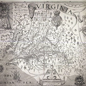
Map of Virginia, discovered and described by Captain John Smith, 1606

![]()
Wall Art and Photo Gifts from Fine Art Finder
Map of Virginia, discovered and described by Captain John Smith, 1606
STC174211 Map of Virginia, discovered and described by Captain John Smith, 1606, engraved by William Hole (fl. 1607-24), published 1612 (engraving) (see also 174212) by Smith, John (1580-1631) (after); Private Collection; (add.info.: John Smith went to Virginia with first settlers 1606; Captured by Powhatan, Chief of Algonquian tribes of Powhatan Confederation 1607 (see top left); saved by Pocahontas, daughter of Powhatan; ); The Stapleton Collection; English, out of copyright
Media ID 23355242
© The Stapleton Collection / Bridgeman Images
Cartographer Chesapeake Bay Jamestown Susquehanna Tribe Mapped
FEATURES IN THESE COLLECTIONS
> Arts
> Artists
> H
> William Hole
> Fine Art Finder
> Artists
> French School
> Fine Art Finder
> Artists
> John (after) Smith
> Fine Art Finder
> Maps (celestial & Terrestrial)
> North America
> United States of America
> Virginia
> Chesapeake
EDITORS COMMENTS
This print showcases the historic "Map of Virginia, discovered and described by Captain John Smith" from 1606. Engraved by William Hole and published in 1612, this intricate map provides a fascinating glimpse into the early exploration of America. Captain John Smith, an English cartographer and adventurer, embarked on a journey to Virginia with the first settlers in 1606. The map depicts his remarkable encounters with the native tribes of the region, including a depiction of Powhatan, Chief of Algonquian tribes who captured Smith in 1607. However, it was Pocahontas, Powhatan's daughter, who famously saved Smith from execution. This pivotal moment is symbolized in the top left corner of the map - a testament to their extraordinary encounter. The Map of Virginia not only offers geographical details but also serves as an invaluable historical document showcasing early colonial life at Jamestown and its surroundings. It beautifully captures both land and sea features such as Chesapeake Bay and Susquehanna River. As we delve into this print from Fine Art Finder's private collection, we are transported back to a time when exploration was filled with wonderment and danger. It reminds us that history is shaped by individuals like Captain John Smith who ventured into unknown territories to expand our understanding of the world around us.
MADE IN THE USA
Safe Shipping with 30 Day Money Back Guarantee
FREE PERSONALISATION*
We are proud to offer a range of customisation features including Personalised Captions, Color Filters and Picture Zoom Tools
SECURE PAYMENTS
We happily accept a wide range of payment options so you can pay for the things you need in the way that is most convenient for you
* Options may vary by product and licensing agreement. Zoomed Pictures can be adjusted in the Cart.