Home > Arts > Artists > I > Indian School Indian School
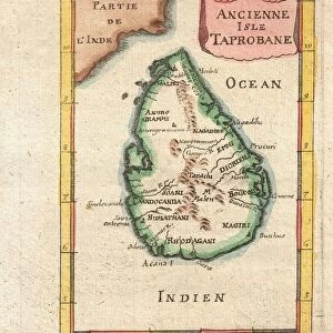
Map of the Island of Taprobana

![]()
Wall Art and Photo Gifts from Fine Art Finder
Map of the Island of Taprobana
3786002 Map of the Island of Taprobana by French School, (19th century); (add.info.: Map of the Island of Taprobana - from reduced fac-simile of map in Ptolemy's Georgraphy, Latin edition, 1492. Given by Nicholas Germain to Pope Paul II. Historical island in Indian Ocean. P: Greek - Roman citizen of Egypt, mathematician, astronomer and geographer, c. AD 90 - c. AD 16.
Science and Literature in the Middle Ages by Paul Lacroix, 1878..P. 289); Lebrecht History
Media ID 31725960
© Lebrecht History / Bridgeman Images
Fifteenth Islands Place Places Tint Tinted 15th 15 Xv Xvth Fifteenth Century Francais
FEATURES IN THESE COLLECTIONS
> Africa
> Egypt
> Related Images
> Arts
> Artists
> I
> Indian School Indian School
> Arts
> Artists
> I
> Italian School Italian School
> Arts
> Literature
> Europe
> Greece
> Related Images
> Europe
> Italy
> Lazio
> Rome
> Fine Art Finder
> Artists
> French School
EDITORS COMMENTS
This print showcases a fascinating piece of history - the Map of the Island of Taprobana. Created by an unknown French artist in the 19th century, this engraving is based on a reduced fac-simile of a map found in Ptolemy's Geography, Latin edition from 1492. The original map was gifted to Pope Paul II by Nicholas Germain and depicts the historical island located in the Indian Ocean. The intricate details and delicate tinting bring this ancient cartographic treasure to life. It transports us back to the Middle Ages, when science and literature flourished under Greek-Roman mathematician, astronomer, and geographer Claudius Ptolemy. As we gaze upon this artwork, we are reminded of the significance maps held during that time period. They were not only tools for navigation but also windows into unexplored lands and cultures. This particular map captures our imagination with its depiction of Taprobana as it existed centuries ago. The combination of French craftsmanship and Italian influence is evident in every stroke, showcasing both artistic skill and historical accuracy. It serves as a testament to how art can preserve knowledge across generations. Whether you are an enthusiast for ancient civilizations or simply appreciate fine artistry, this print offers a glimpse into a world long gone but forever immortalized through meticulous cartography.
MADE IN THE USA
Safe Shipping with 30 Day Money Back Guarantee
FREE PERSONALISATION*
We are proud to offer a range of customisation features including Personalised Captions, Color Filters and Picture Zoom Tools
SECURE PAYMENTS
We happily accept a wide range of payment options so you can pay for the things you need in the way that is most convenient for you
* Options may vary by product and licensing agreement. Zoomed Pictures can be adjusted in the Cart.