Home > Arts > Artists > B > Baptista Boazio
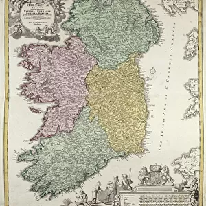
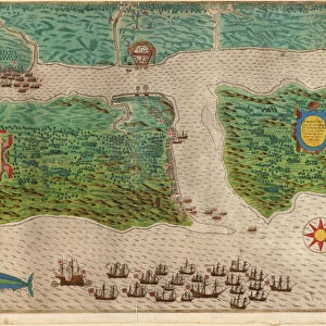
Route of Drakes voyage across the Atlantic Ocean, 1586 (coloured engraving)
")
![]()
Wall Art and Photo Gifts from Fine Art Finder
Route of Drakes voyage across the Atlantic Ocean, 1586 (coloured engraving)
5242110 Route of Drakes voyage across the Atlantic Ocean, 1586 (coloured engraving) by Boazio, Baptista (fl.1588-1606); Private Collection; (add.info.: From Map and views illustrating Sir Francis Drakes West Indian voyage, 1585-86 made by an English expedition fleet of 23 ships lead by Drake from Plymouth back to Portsmouth during the Anglo-Spanish War.); Italian, out of copyright
Media ID 22781406
© Bridgeman Images
Americas Atlantic Caribbean Cartographic Cartography Elizabethan Expansion Expedition Fleet Hydrography Islands Navigation New World Plymouth Portsmouth Route Sea Chart Voyage West Indian West Indies
FEATURES IN THESE COLLECTIONS
> Africa
> Related Images
> Africa
> South Africa
> Maps
> Africa
> South Africa
> Related Images
> Animals
> Mammals
> Pitheciidae
> Baptista
> Arts
> Artists
> B
> Baptista Boazio
> Arts
> Artists
> D
> Francis Drake
> Arts
> Artists
> O
> Oceanic Oceanic
> Europe
> Italy
> Related Images
> Fine Art Finder
> Artists
> Baptista Boazio
> Fine Art Finder
> Artists
> English School
EDITORS COMMENTS
This coloured engraving depicts the route of Sir Francis Drake's historic voyage across the Atlantic Ocean in 1586. Created by Italian cartographer Baptista Boazio, this print showcases the remarkable journey undertaken by an English expedition fleet led by Drake during the Anglo-Spanish War. The intricate details of this artwork highlight not only the geographical aspects but also the significant historical context surrounding Drake's exploration. The map reveals various islands and coastlines, including those in the Caribbean and West Indies, as well as parts of Africa and North America. As we delve into this visual representation, we are transported back to a time when maritime expeditions were at their peak. This engraving serves as a testament to England's naval prowess and its thirst for discovery during the Elizabethan era. The presence of ships on this map symbolizes both expansion and conquest, showcasing England's determination to explore new territories while engaging with Spanish forces. It is fascinating to see how these voyages paved the way for colonialism and shaped our understanding of navigation in that period. Through Boazio's skilled craftsmanship, we can almost feel ourselves aboard one of those vessels sailing across uncharted waters towards unknown horizons. This print offers us a glimpse into history – a vivid reminder of humanity's relentless pursuit for knowledge and adventure.
MADE IN THE USA
Safe Shipping with 30 Day Money Back Guarantee
FREE PERSONALISATION*
We are proud to offer a range of customisation features including Personalised Captions, Color Filters and Picture Zoom Tools
SECURE PAYMENTS
We happily accept a wide range of payment options so you can pay for the things you need in the way that is most convenient for you
* Options may vary by product and licensing agreement. Zoomed Pictures can be adjusted in the Cart.