Home > Animals > Mammals > Spalacidae > Antiquus
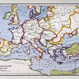
Maps showing the extent of realms of the known World in ancient times (coloured engraving)
")
![]()
Wall Art and Photo Gifts from Fine Art Finder
Maps showing the extent of realms of the known World in ancient times (coloured engraving)
7148245 Maps showing the extent of realms of the known World in ancient times (coloured engraving) by Kiepert, Heinrich (1818-99); Private Collection; (add.info.: Maps showing the extent of realms of the known World in ancient times. Illustration from Atlas Antiquus, Twelve Maps of the Ancient World for Schools and Colleges, by Dr Henry Kiepert (Dietrich Reimer, Berlin, c1889).); © Look and Learn
Media ID 25216288
© Look and Learn / Bridgeman Images
Assyria Assyrians Atlas China Chinese City Map City Plan General Map Latium Street Plan Afica Central Africa Chineses Egyptians Inida Mythological Character Mythological Figure Myths Pagan Paganism Pagans Polytheism Polytheist
FEATURES IN THESE COLLECTIONS
> Africa
> Egypt
> Related Images
> Africa
> Related Images
> Animals
> Mammals
> Spalacidae
> Antiquus
> Arts
> Artists
> I
> Indian School Indian School
> Arts
> Artists
> I
> Italian School Italian School
> Arts
> Artists
> R
> Roman Roman
> Arts
> Portraits
> Pop art gallery
> Street art portraits
> Fine Art Finder
> Artists
> English School
> Fine Art Finder
> Artists
> Heinrich Kiepert
EDITORS COMMENTS
This print showcases the ancient world as depicted in a series of beautifully colored maps. Created by Heinrich Kiepert, a renowned cartographer from the 19th century, these maps were part of his Atlas Antiquus collection designed for educational purposes. The intricate engravings depict the extent of various realms and civilizations known to exist during ancient times. From Africa to Asia, each region is meticulously detailed, offering a glimpse into the diverse cultures and landscapes that shaped our history. In this print, we see mythological figures and characters intertwined with real geographical features. The presence of Assyria highlights its significance in ancient mythology and religion. Paganism and polytheism are also represented through symbols associated with different belief systems. The vibrant colors used in this engraving bring life to the maps, enhancing their visual appeal while providing valuable information about historical boundaries and territories. Europe is prominently featured alongside Egypt, India, China, and Central Africa – regions that played crucial roles in shaping civilization as we know it today. As we explore this artwork from Bridgeman Images' private collection, we are reminded of how far humanity has come since these ancient times. It serves as a testament to our curiosity about the world around us and our continuous quest for knowledge throughout history.
MADE IN THE USA
Safe Shipping with 30 Day Money Back Guarantee
FREE PERSONALISATION*
We are proud to offer a range of customisation features including Personalised Captions, Color Filters and Picture Zoom Tools
SECURE PAYMENTS
We happily accept a wide range of payment options so you can pay for the things you need in the way that is most convenient for you
* Options may vary by product and licensing agreement. Zoomed Pictures can be adjusted in the Cart.