Home > Maps and Charts > Americas
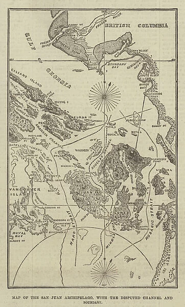
Map of the San Juan Archipelago, with the Disputed Channel and Boundary (engraving)
![]()

Wall Art and Photo Gifts from Fine Art Finder
Map of the San Juan Archipelago, with the Disputed Channel and Boundary (engraving)
1588983 Map of the San Juan Archipelago, with the Disputed Channel and Boundary (engraving) by English School, (19th century); Private Collection; (add.info.: Map of the San Juan Archipelago, with the Disputed Channel and Boundary. Illustration for The Illustrated London News, 2 November 1872.
English School (19th Century)); Look and Learn / Illustrated Papers Collection
Media ID 22546906
© Look and Learn / Illustrated Papers Collection / Bridgeman Images
FEATURES IN THESE COLLECTIONS
> Arts
> Artists
> Related Images
> Fine Art Finder
> Artists
> English School
> North America
> Related Images
EDITORS COMMENTS
This engraving from the 19th century showcases a detailed map of the San Juan Archipelago, complete with the Disputed Channel and Boundary. The print, now part of a private collection, offers a glimpse into the historical significance of this region in North America. The map was originally created as an illustration for The Illustrated London News on November 2nd, 1872. Its intricate details highlight the complexity surrounding territorial disputes during that time period. As we delve into this piece, we are transported back to an era where boundaries were being contested and debated. The disputed channel stands out prominently on the map, serving as a reminder of past conflicts and unresolved tensions. Through its meticulous craftsmanship, this engraving provides us with valuable insight into both cartography and history. It allows us to explore not only geographical features but also political dynamics that shaped the San Juan Archipelago. Whether you are an avid collector or simply fascinated by maps and their stories, this print is sure to captivate your imagination. It serves as a testament to human curiosity and our constant quest for knowledge about our surroundings. Bridgeman Images has preserved this remarkable piece of artistry from Fine Art Finder's Look and Learn / Illustrated Papers Collection for all enthusiasts to appreciate.
MADE IN THE USA
Safe Shipping with 30 Day Money Back Guarantee
FREE PERSONALISATION*
We are proud to offer a range of customisation features including Personalised Captions, Color Filters and Picture Zoom Tools
SECURE PAYMENTS
We happily accept a wide range of payment options so you can pay for the things you need in the way that is most convenient for you
* Options may vary by product and licensing agreement. Zoomed Pictures can be adjusted in the Cart.


