Home > Europe > France > Heritage Sites > Lagoons of New Caledonia: Reef
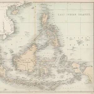
Map of New Guinee and New Caledonia, years 1870. 19th century lithograph

![]()
Wall Art and Photo Gifts from Fine Art Finder
Map of New Guinee and New Caledonia, years 1870. 19th century lithograph
NWI4879110 Map of New Guinee and New Caledonia, years 1870. 19th century lithograph.; (add.info.: Map of New Guinee and New Caledonia, years 1870. 19th century lithograph.); Photo © North Wind Pictures
Media ID 38332476
© © North Wind Pictures / Bridgeman Images
Dom Tom Guinee New Caledonia Papua New Guinea Geographical Map
FEATURES IN THESE COLLECTIONS
> Europe
> France
> Heritage Sites
> Lagoons of New Caledonia: Reef
> Fine Art Finder
> Artists
> Emile Andre Schefer
> Maps and Charts
> Early Maps
> Oceania
> Papua New Guinea
> Maps
> Oceania
> Papua New Guinea
> Related Images
EDITORS COMMENTS
This stunning lithograph print from the 19th century showcases a detailed map of New Guinea and New Caledonia, dating back to the year 1870. The intricate lines and vibrant colors bring this historical geographical map to life, providing a glimpse into the past of these Pacific islands.
New Guinea and New Caledonia are depicted with precision, highlighting their coastlines, rivers, mountains, and other geographical features. This map serves as a valuable resource for understanding the layout of these regions during this time period.
The French influence on New Caledonia is evident in this map, showcasing its status as a French territory in the 19th century. The inclusion of both islands on one lithograph provides a comprehensive view of Oceania during this era.
As we gaze upon this piece of history, we are transported back to a time when exploration and discovery were at the forefront of human endeavors. The attention to detail in this lithograph reflects the dedication of the engraver who meticulously crafted it.
Overall, this Map of New Guinea and New Caledonia from 1870 is not just a visual representation but also a window into our past – reminding us of how far we have come in terms of cartography and geographic knowledge.
MADE IN THE USA
Safe Shipping with 30 Day Money Back Guarantee
FREE PERSONALISATION*
We are proud to offer a range of customisation features including Personalised Captions, Color Filters and Picture Zoom Tools
SECURE PAYMENTS
We happily accept a wide range of payment options so you can pay for the things you need in the way that is most convenient for you
* Options may vary by product and licensing agreement. Zoomed Pictures can be adjusted in the Cart.