Home > Arts > Artists > M > Samuel Augustus Mitchell
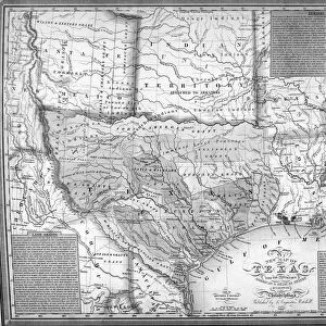
Mitchells Map of Texas, 1835 (litho) (detail of 241191)
 (detail of 241191)")
![]()
Wall Art and Photo Gifts from Fine Art Finder
Mitchells Map of Texas, 1835 (litho) (detail of 241191)
DHS241192 Mitchells Map of Texas, 1835 (litho) (detail of 241191) by American School, (19th century); Dallas Historical Society, Texas, USA; (add.info.: Samuel Augustus Mitchell (1792-1868); ); eDallas Historical Society; American, out of copyright
Media ID 23363556
© Dallas Historical Society / Bridgeman Images
Deep South Gulf Of Mexico New Mexico Southern States State States Territories Territory Texan Topographical
FEATURES IN THESE COLLECTIONS
> Arts
> Artists
> I
> Indian School Indian School
> Arts
> Artists
> M
> Mexican School Mexican School
> Arts
> Artists
> M
> Samuel Augustus Mitchell
> Fine Art Finder
> Artists
> American School
> Fine Art Finder
> Maps (celestial & Terrestrial)
> Maps and Charts
> Early Maps
> North America
> Mexico
> Related Images
> North America
> United States of America
> Maps
> North America
> United States of America
> New Mexico
> Related Images
> North America
> United States of America
> Texas
> Dallas
> North America
> United States of America
> Texas
> Related Images
EDITORS COMMENTS
This print showcases a detailed section of "Mitchells Map of Texas, 1835 (litho)" by the American School from the 19th century. Preserved by the Dallas Historical Society in Texas, USA, this historical artifact offers a glimpse into Samuel Augustus Mitchell's cartographic expertise. The lithograph presents an intricate topographical view of Texas and its surrounding areas. From the vast territories to the meandering rivers, every detail is meticulously engraved on this map. It not only highlights the southern states but also encompasses New Mexico Territory and stretches all the way to the Gulf of Mexico. As we delve deeper into this image, we can observe how Mitchell skillfully captures both land and sea elements. The Texan coastline is beautifully depicted with its shoreline meeting the vast expanse of water in a harmonious blend. This maritime representation adds depth and dimension to his work. Moreover, this print allows us to appreciate Mitchell's dedication to accuracy as he includes Indian territories within his map. By doing so, he acknowledges their presence and significance in shaping Texas' history. Overall, this stunning lithograph serves as a testament to Mitchell's talent as a cartographer during that era. Its preservation at eDallas Historical Society ensures that future generations can admire and study it for years to come.
MADE IN THE USA
Safe Shipping with 30 Day Money Back Guarantee
FREE PERSONALISATION*
We are proud to offer a range of customisation features including Personalised Captions, Color Filters and Picture Zoom Tools
FREE COLORIZATION SERVICE
You can choose advanced AI Colorization for this picture at no extra charge!
SECURE PAYMENTS
We happily accept a wide range of payment options so you can pay for the things you need in the way that is most convenient for you
* Options may vary by product and licensing agreement. Zoomed Pictures can be adjusted in the Cart.