Home > Arts > Artists > C > Abraham Cresques
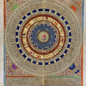
Detail from the Catalan Atlas, Sheet 6, showing Mansa Musa enthroned

![]()
Wall Art and Photo Gifts from Fine Art Finder
Detail from the Catalan Atlas, Sheet 6, showing Mansa Musa enthroned
5043052 Detail from the Catalan Atlas, Sheet 6, showing Mansa Musa enthroned, 1375 (pen with coloured inks on parchment) by Cresques, Abraham (1325-87); Bibliotheque Nationale, Paris, France; (add.info.: World map made in Majorca, with Jerusalem close to the centre, attributed to a Jewish cartographer in the service of the king of Aragon, covers an area from the Atlantic to China, from Scandinavia to the Rio Oro in Africa. The King of Mali, " Musse Melly" (Mansa Musa) holds a sceptre with a fleur-de-lys and a golden disc. He was known to control a large part of Africa, from Gambia and Senegal to Gao on the Niger, and had access to some of its richest gold deposits.); Spanish, out of copyright
Media ID 22565352
© Bridgeman Images
Atlas Atlas Mountains Cartography Catalan Catalan Atlas Catalonia Compass Compass Lines Cosmography Early Map Hydrography Majorcan Mali Mansa Musa Mappa Mundi Mediterranean Nautical Nautical Charts Navigation Navigational Portolan River Niger Sea Chart Silk Road Spice Trade Spices Vellum World Map Western Sahara
FEATURES IN THESE COLLECTIONS
> Africa
> The Gambia
> Maps
> Africa
> Western Sahara
> Maps
> Animals
> Mammals
> Soricidae
> Niger
> Arts
> Artists
> C
> Abraham Cresques
> Arts
> Artists
> N
> Aert van der Neer
> Arts
> Landscape paintings
> Waterfall and river artworks
> River artworks
> Asia
> China
> China Heritage Sites
> Silk Roads: the Routes Network of
> Fine Art Finder
> Artists
> Abraham Cresques
> Fine Art Finder
> Artists
> Aert van der Neer
EDITORS COMMENTS
This print showcases a mesmerizing detail from the Catalan Atlas, Sheet 6, depicting Mansa Musa enthroned. Created in 1375 by Abraham Cresques, a Jewish cartographer in the service of the king of Aragon, this world map offers a remarkable glimpse into medieval cartography. The intricate pen and colored ink work on parchment transports us to an era when exploration and trade routes were being discovered and established. The map covers an extensive area from Scandinavia to China, with Jerusalem positioned near the center. It encompasses diverse regions such as Western Sahara, Atlas Mountains, River Niger, and North Africa's coastline. At its heart lies Mansa Musa himself – "Musse Melly" the King of Mali – depicted holding a scepter adorned with a fleur-de-lys and golden disc. Known for his vast control over parts of Africa stretching from Gambia to Gao on the Niger River, Mansa Musa had access to abundant gold deposits that contributed to his immense wealth. This image not only captures historical geography but also reflects significant aspects of medieval commerce and navigation. It hints at spice trade routes along the Silk Road while showcasing major ports like Catalonia involved in maritime activities during that time. Preserved within Spain's Bibliothèque Nationale since its creation in Majorca centuries ago, this extraordinary piece serves as both an invaluable artifact and testament to human curiosity about our world's vastness.
MADE IN THE USA
Safe Shipping with 30 Day Money Back Guarantee
FREE PERSONALISATION*
We are proud to offer a range of customisation features including Personalised Captions, Color Filters and Picture Zoom Tools
SECURE PAYMENTS
We happily accept a wide range of payment options so you can pay for the things you need in the way that is most convenient for you
* Options may vary by product and licensing agreement. Zoomed Pictures can be adjusted in the Cart.