Home > Arts > Artists > C > Abraham Cresques
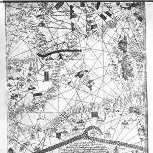
Catalan Atlas, Sheet 8 (pen with coloured inks on parchment)
")
![]()
Wall Art and Photo Gifts from Fine Art Finder
Catalan Atlas, Sheet 8 (pen with coloured inks on parchment)
5054649 Catalan Atlas, Sheet 8 (pen with coloured inks on parchment) by Cresques, Abraham (1325-87); Bibliotheque Nationale, Paris, France; (add.info.: World map made in Majorca, with Jerusalem close to the centre, attributed to the Jewish cartographer Abraham Cresques in the service of the king of Aragon. One of the few surviving examples of medieval cartography, richly illustrated and covers an area from the Atlantic to China, from Scandinavia to the Rio Oro in Africa in six parchment-covered wooden panels.); Spanish, out of copyright
Media ID 23258892
© Bridgeman Images
Atlas Cartography Catalan Catalan Atlas Catalonia Compass Compass Lines Cosmography Early Map Hydrography Jerusalem Majorcan Mappa Mundi Mediterranean Nautical Nautical Charts Navigation Navigational Portolan Red Sea Sea Chart Silk Road Spice Trade Spices Vellum World Map
FEATURES IN THESE COLLECTIONS
> Arts
> Art Movements
> Medieval Art
> Arts
> Artists
> C
> Abraham Cresques
> Arts
> Artists
> O
> Oceanic Oceanic
> Asia
> China
> China Heritage Sites
> Silk Roads: the Routes Network of
> Asia
> Turkey
> Related Images
> Europe
> France
> Paris
> Maps
> Fine Art Finder
> Artists
> Abraham Cresques
EDITORS COMMENTS
This print showcases the Catalan Atlas, Sheet 8, a remarkable piece of medieval cartography created by Abraham Cresques in Majorca. The map, made with pen and colored inks on parchment, is now housed at the Bibliotheque Nationale in Paris. The Catalan Atlas is a rare surviving example of its kind and offers an intricate depiction of the world during the 14th century. Spanning from Scandinavia to China and from the Atlantic to Africa's Rio Oro, this six-panel masterpiece provides a comprehensive view of global geography. Attributed to Cresques, who served as a Jewish cartographer for the king of Aragon, this map holds immense historical significance. Jerusalem takes center stage on the atlas, reflecting its importance as a focal point for trade routes and cultural exchange during that era. Richly illustrated with nautical charts and hydrographic details, it highlights key regions involved in maritime exploration and commerce such as Spain's spice trade routes along the Silk Road. The use of vellum adds an air of elegance to this navigational marvel. With meticulous attention to detail and precise compass lines guiding seafarers across vast oceans, this manuscript represents not only an invaluable tool for navigation but also serves as a testament to human curiosity about uncharted territories. Immerse yourself in history with this extraordinary image capturing one panel from Cresques' Catalan Atlas - an awe-inspiring blend of artistry and scientific knowledge that continues to fascinate scholars today.
MADE IN THE USA
Safe Shipping with 30 Day Money Back Guarantee
FREE PERSONALISATION*
We are proud to offer a range of customisation features including Personalised Captions, Color Filters and Picture Zoom Tools
SECURE PAYMENTS
We happily accept a wide range of payment options so you can pay for the things you need in the way that is most convenient for you
* Options may vary by product and licensing agreement. Zoomed Pictures can be adjusted in the Cart.