Home > North America > Canada > Lakes > Lake Huron
EXPL2A-00350

![]()
Wall Art and Photo Gifts from North Wind
EXPL2A-00350
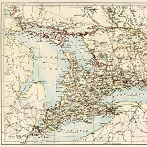
French map of the Great Lakes and upper Mississippi River region, circa 1700.
Hand-colored 19th-century woodcut reproduction
North Wind Picture Archives brings history to life with stock images and hand-colored illustrations
Media ID 5880788
© North Wind Picture Archives
1600s 1700s 17th Century 18th Century Canada Canadian Colonial Colony Discovery Document Exploration Explore French French Canada Frontier Great Lakes Illinois Lake Michigan Lake Superior Michigan Mid West Minnesota Mississippi River New France Ohio River Ontario River Wild Wilderness Wisconsin 1700 Lake Huron
FEATURES IN THESE COLLECTIONS
> Arts
> Landscape paintings
> Waterfall and river artworks
> River artworks
> Europe
> France
> Lakes
> Related Images
> North America
> Canada
> Lakes
> Lake Huron
> North America
> Canada
> Lakes
> Lake Superior
> North America
> Canada
> Maps
> North Wind Picture Archives
> Exploration
> North Wind Picture Archives
> Maps
EDITORS COMMENTS
This print showcases a hand-colored 19th-century woodcut reproduction of the EXPL2A-00350, a French map depicting the Great Lakes and upper Mississippi River region circa 1700. Steeped in history and charm, this vintage piece takes us back to the wild and untamed wilderness of North America's frontier. The intricate illustration transports us to an era of exploration and discovery, where colonial powers like France were vying for control over vast territories. The map beautifully captures the rich tapestry of this uncharted land, from Minnesota to Illinois, Ontario to Michigan, Wisconsin to Ohio River. It offers a fascinating glimpse into the early days of settlement in New France during the late 17th century. With its vibrant colors and meticulous details, this artwork serves as both a valuable historical document and an exquisite piece of art. It evokes feelings of wonderment at how our continent looked centuries ago before modern development took hold. As we gaze upon this remarkable print, we are reminded of the enduring legacy left by those who ventured into these lands long ago. It is a testament to their bravery and curiosity that we can now appreciate their journeys through such visually stunning representations. Whether you are an avid history enthusiast or simply captivated by North America's majestic landscapes, this French map will transport you back in time while igniting your imagination with tales from our past.
MADE IN THE USA
Safe Shipping with 30 Day Money Back Guarantee
FREE PERSONALISATION*
We are proud to offer a range of customisation features including Personalised Captions, Color Filters and Picture Zoom Tools
SECURE PAYMENTS
We happily accept a wide range of payment options so you can pay for the things you need in the way that is most convenient for you
* Options may vary by product and licensing agreement. Zoomed Pictures can be adjusted in the Cart.