Fraud Blocker Skip to main content

Home > Europe > Vatican City > Maps

Maps Collection

Vatican City is a walled enclave located within the city of Rome, Italy

Choose a picture from our Maps Collection for your Wall Art and Photo Gifts

44 items

Background imageMaps Collection: Rome City Centre Street Map

Rome City Centre Street Map
A detailed street level map of central Rome. Covers from Pinciano in the north to San Saba in the south and from Viale Pretoriano in the east and includes all of the Vatican city in the west

Background imageMaps Collection: City map of Rome, lithograph, published in 1878

City map of Rome, lithograph, published in 1878
City map of Rome, Italy. Lithograph, published in 1878

Background imageMaps Collection: The Gallery of Geographic Maps, interior of Vatican Museums. Vatican City

The Gallery of Geographic Maps, interior of Vatican Museums. Vatican City State of the Vatican City Vatican Museums, Gallery of Geographic Maps Gallery Late Renaissance, Renaissance

Background imageMaps Collection: Gallery of Maps, Vatican, published in 1878

Gallery of Maps, Vatican, published in 1878
The Gallery of Maps (Latin: Galleria delle carte geografiche) in the Vatican. Wood engraving, published in 1878

Background imageMaps Collection: 16th century map of Venice

16th century map of Venice showing the lagoon. Venice is a coastal city in the north-east of Italy. The main bulk of Venice is in the upper frame of the image

Background imageMaps Collection: Siege of Malta, detail from the Galleria delle Carte Geografiche, 1580-83

Siege of Malta, detail from the Galleria delle Carte Geografiche, 1580-83
XIR259885 Siege of Malta, detail from the Galleria delle Carte Geografiche, 1580-83 (fresco) (see also 260199) by Italian School, (16th century); Vatican Museums and Galleries

Background imageMaps Collection: Rome in the birds eye view, published in 1878

Rome in the birds eye view, published in 1878
Rome in the birds eye view with the known historic buildings and places. Wood engraving, published in 1878

Background imageMaps Collection: 16th Century Plan of Rome

16th Century Plan of Rome
16th century plan of Rome. Details from the map of Latium et Sabina (Southern Lazio), in the Gallery of Maps in the Vatican Museum.The Gallery of Maps holds maps which were commissioned between 1578

Background imageMaps Collection: Rome on the Tiber, The Vatican, 1700

Rome on the Tiber, The Vatican, 1700
2900912 Rome on the Tiber, The Vatican, 1700; (add.info.: Rome on the Tiber, The Vatican, 1700.); Buyenlarge Archive/UIG

Background imageMaps Collection: George Bradshaws Plan of Rome, Italy 1896

George Bradshaws Plan of Rome, Italy 1896
This is a very detailed Plan of Rome showing the streets, canals, principal buildings, railways and railway stations, as well as the many ancient Roman sites

Background imageMaps Collection: Frescoes on the ceiling of the Gallery of Maps, Vatican Museum, Rome, Lazio, Italy

Frescoes on the ceiling of the Gallery of Maps, Vatican Museum, Rome, Lazio, Italy, Europe

Background imageMaps Collection: Gallery of Maps in the Vatican Museums, Vatican City

Gallery of Maps in the Vatican Museums, Vatican City State of the Vatican City Musei Vaticani Gallery Late Renaissance, Renaissance, Renaissance-Baroque styles and periods, Europe

Background imageMaps Collection: Chariot drawn by griffins, detail from the Galleria delle Carte Geografiche, 1580-83

Chariot drawn by griffins, detail from the Galleria delle Carte Geografiche, 1580-83
SAL55099 Chariot drawn by griffins, detail from the Galleria delle Carte Geografiche, 1580-83 by Danti, Egnazio (1536-86); Vatican Museums and Galleries

Background imageMaps Collection: Map of Florence, 15th century

Map of Florence, 15th century. View of the city showing the River Arno and Brunelleschis Duomo. From the Gallery of Maps, Vatican Museum, Vatican City, Italy

Background imageMaps Collection: Jean III Sobieski (1629-1696) send a message of victory to the Pope Innocent XI after the Vienna

Jean III Sobieski (1629-1696) send a message of victory to the Pope Innocent XI after the Vienna battle
FIA5410110 Jean III Sobieski (1629-1696) send a message of victory to the Pope Innocent XI after the Vienna battle, 1883 (oil on canvas) by Matejko

Background imageMaps Collection: Bearded Dionysus and Satyr (engraving)

Bearded Dionysus and Satyr (engraving)
7193926 Bearded Dionysus and Satyr (engraving) by European School, (19th century); Private Collection; (add.info.: Bearded Dionysus and Satyr)

Background imageMaps Collection: The Vatican Gardens, Rome, Fountain in Court of Villino Medici (b / w photo)

The Vatican Gardens, Rome, Fountain in Court of Villino Medici (b / w photo)
7169260 The Vatican Gardens, Rome, Fountain in Court of Villino Medici (b/w photo) by Latham, Charles (d.1912); Private Collection; (add.info.: The Vatican Gardens, Rome)

Background imageMaps Collection: Birds Eye View of Rome, 1553. Creator: Giulio de Musi

Birds Eye View of Rome, 1553. Creator: Giulio de Musi
Birds Eye View of Rome, 1553

Background imageMaps Collection: The Tyrrhenian Sea, detail from the Galleria delle Carte Geografiche, 1580-83

The Tyrrhenian Sea, detail from the Galleria delle Carte Geografiche, 1580-83
SAL205557 The Tyrrhenian Sea, detail from the Galleria delle Carte Geografiche, 1580-83 by Danti, Egnazio (1536-86); Vatican Museums and Galleries

Background imageMaps Collection: A galleon in the Adriatic, detail from the Galleria delle Carte Geografiche

A galleon in the Adriatic, detail from the Galleria delle Carte Geografiche
SAL205552 A galleon in the Adriatic, detail from the Galleria delle Carte Geografiche, 1580-83 by Danti, Egnazio (1536-86); Vatican Museums and Galleries

Background imageMaps Collection: Venice, detail from the Galleria dell Carte Geografiche, 1580-83

Venice, detail from the Galleria dell Carte Geografiche, 1580-83
SAL55094 Venice, detail from the Galleria dell Carte Geografiche, 1580-83 by Danti, Egnazio (1536-86); Vatican Museums and Galleries

Background imageMaps Collection: Bologna, detail from the Galleria delle Carte Geografiche, 1580-83

Bologna, detail from the Galleria delle Carte Geografiche, 1580-83
SAL205563 Bologna, detail from the Galleria delle Carte Geografiche, 1580-83 by Danti, Egnazio (1536-86); Vatican Museums and Galleries

Background imageMaps Collection: Map of the city of Bologna, (fresco, 1581)

Map of the city of Bologna, (fresco, 1581)
LRI4595477 Map of the city of Bologna, (fresco, 1581) by Italian School, (16th century); Musei e Gallerie Pontificie, Musei Vaticani

Background imageMaps Collection: St. Mark the Evangelist, detail from the Galleria delle Carte Geografiche

St. Mark the Evangelist, detail from the Galleria delle Carte Geografiche
SAL55100 St. Mark the Evangelist, detail from the Galleria delle Carte Geografiche, 1580-83 by Danti, Egnazio (1536-86); Vatican Museums and Galleries

Background imageMaps Collection: The Roads of Rome, during the reign of Pope Sixtus V (fresco)

The Roads of Rome, during the reign of Pope Sixtus V (fresco)
828666 The Roads of Rome, during the reign of Pope Sixtus V (fresco) by Italian School, (16th century); Sistine Hall, Vatican Library

Background imageMaps Collection: Piran, detail from the Galleria delle Carte Geografiche, 1580-83

Piran, detail from the Galleria delle Carte Geografiche, 1580-83
SAL205559 Piran, detail from the Galleria delle Carte Geografiche, 1580-83 by Danti, Egnazio (1536-86); Vatican Museums and Galleries

Background imageMaps Collection: Galleon, detail from the Galleria delle Carte Geografiche, 1580-83

Galleon, detail from the Galleria delle Carte Geografiche, 1580-83
SAL55093 Galleon, detail from the Galleria delle Carte Geografiche, 1580-83 by Danti, Egnazio (1536-86); Vatican Museums and Galleries

Background imageMaps Collection: Speculum Romanae Magnificentiae: View of Rome from the North, 1561. 1561

Speculum Romanae Magnificentiae: View of Rome from the North, 1561. 1561
Speculum Romanae Magnificentiae: View of Rome from the North, 1561

Background imageMaps Collection: Speculum Romanae Magnificentiae: View of Rome from the East, 16th century. 16th century

Speculum Romanae Magnificentiae: View of Rome from the East, 16th century. 16th century
Speculum Romanae Magnificentiae: View of Rome from the East, 16th century

Background imageMaps Collection: Roma - Vatican Palace - Gallery of Geographical Maps, 1910

Roma - Vatican Palace - Gallery of Geographical Maps, 1910. Drawn by the Dominican Father I. Danti for pope Gregory XIII. From Cento Vedute Classiche di Roma. [Enrico Verdesi, Rome, 1910]

Background imageMaps Collection: Map of Florence, 15th century

Map of Florence, 15th century. Pictorial Italian map showing the layout of the city. From the Gallery of Maps, Vatican Museum, Rome

Background imageMaps Collection: Speculum Romanae Magnificentiae: Plan of St. Peter s, 1569. Creator: Etienne Duperac

Speculum Romanae Magnificentiae: Plan of St. Peter s, 1569. Creator: Etienne Duperac
Speculum Romanae Magnificentiae: Plan of St. Peter s, 1569

Background imageMaps Collection: Speculum Romanae Magnificentiae: Plan of St. Peter s, 1569. Creator: Etienne Duperac

Speculum Romanae Magnificentiae: Plan of St. Peter s, 1569. Creator: Etienne Duperac
Speculum Romanae Magnificentiae: Plan of St. Peter s, 1569

Background imageMaps Collection: Map Vatican Belvedere gardens Pianta alzata del giardino di Belvedere del Palazzo

Map Vatican Belvedere gardens Pianta alzata del giardino di Belvedere del Palazzo
Map of the Vatican Belvedere gardens Pianta and alzata del giardino di Belvedere del Palazzo Pontificioin Vaticano (title on object) Gardens in Rome (series title)

Background imageMaps Collection: Frescoes on the ceiling of the Gallery of the Maps, Vatican Museums, Rome, Lazio, Italy, Europe

Frescoes on the ceiling of the Gallery of the Maps, Vatican Museums, Rome, Lazio, Italy, Europe

Background imageMaps Collection: Vatican City country map

Vatican City country map
2011 edition

Background imageMaps Collection: Plan City Rome Part 7 Dedication Camillo Pamphili

Plan City Rome Part 7 Dedication Camillo Pamphili
Artokoloro

Background imageMaps Collection: Le Sette Chiesa di Roma, 1575 (etching) (b / w photo)

Le Sette Chiesa di Roma, 1575 (etching) (b / w photo)
XJF324407 Le Sette Chiesa di Roma, 1575 (etching) (b/w photo) by Lafreri, Antonio (1512-77); Private Collection; (add.info)

Background imageMaps Collection: Map of Malta, detail from the Galleria delle Carte Geografiche, 1580-83

Map of Malta, detail from the Galleria delle Carte Geografiche, 1580-83
XIR260199 Map of Malta, detail from the Galleria delle Carte Geografiche, 1580-83 (fresco) (see 259885 for detail) by Italian School, (16th century); Vatican Museums and Galleries

Background imageMaps Collection: Siege of Malta, detail from the Galleria delle Carte Geografiche, 1580-83

Siege of Malta, detail from the Galleria delle Carte Geografiche, 1580-83
XIR1203438 Siege of Malta, detail from the Galleria delle Carte Geografiche, 1580-83 (fresco) by Italian School, (16th century); Vatican Museums and Galleries

Background imageMaps Collection: Frescoes on the ceiling of the Gallery of the Maps, Vatican Museums, Rome, Lazio, Italy, Europe

Frescoes on the ceiling of the Gallery of the Maps, Vatican Museums, Rome, Lazio, Italy, Europe

Background imageMaps Collection: Italy, Relief Map With Border and Mask

Italy, Relief Map With Border and Mask
Relief map of Italy (with border and mask). This image was compiled from data acquired by landsat 5 & 7 satellites combined with elevation data

Background imageMaps Collection: Map of Vatican City

Map of Vatican City

Background imageMaps Collection: Ancient Port of Fiumicino, fresco by Ignazio Danti

Ancient Port of Fiumicino, fresco by Ignazio Danti
Vatican City State - Vatican Palace - Geographical Maps Gallery. Ignazio Danti (1536-1586), Ancient Port of Fiumicino, fresco


All Professionally Made to Order for Quick Shipping


-

Maps Collection

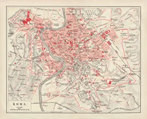
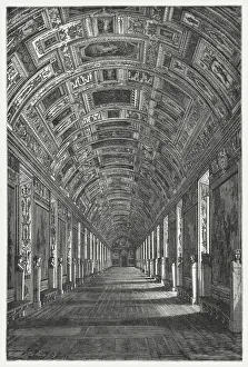
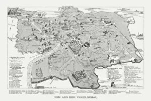
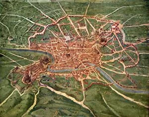
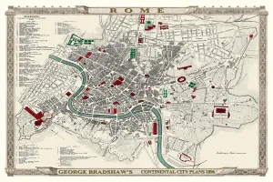
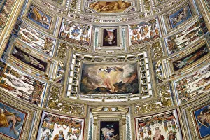
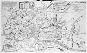
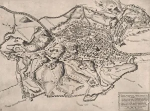
Vatican City is a walled enclave located within the city of Rome, Italy, and is the smallest independent state in the world and serves as the spiritual center of Roman Catholicism. The area is home to many important religious sites, including St. Peter's Basilica, St. Peter's Square and the Sistine Chapel. Maps of Vatican City can be used to explore its history and culture, as well as its current political boundaries and infrastructure. The maps show that Vatican City covers an area of approximately 44 hectares (110 acres) with a population of around 1,000 people living within its walls. They also reveal that it has two main streets: Via della Conciliazione and Via dei Corridori which are lined with shops, restaurants and other attractions for visitors to enjoy while exploring this unique city-state.
+

Our beautiful pictures are available as Framed Prints, Photos, Wall Art and Photo Gifts

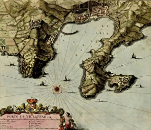
The Maps of Vatican City Europe collection from Media Storehouse is a stunning assortment of wall art and framed prints that showcase the intricate details and beauty of Vatican City. Our collection features a range of maps, including antique maps dating back to the 16th century as well as modern-day cartography. The pieces are carefully curated to highlight the rich history and cultural significance of this iconic city-state. Each map in our collection offers a unique perspective on Vatican City's architecture, landmarks, and surrounding areas. From detailed street layouts to panoramic views, these prints capture the essence of one of Europe's most famous destinations. Whether you're an avid traveler or simply appreciate fine art, our collection is sure to impress. The Maps of Vatican City Europe collection from Media Storehouse provides an excellent opportunity for individuals to bring home a piece of history while adding style and sophistication to their living spaces.
+

What are Maps of Vatican City Europe art prints?

Maps of Vatican City Europe art prints are high-quality reproductions of maps depicting the geography and layout of Vatican City, a sovereign city-state located within Rome, Italy. These prints showcase the intricate details of the city's architecture and landmarks, including St. Peter's Basilica, the Sistine Chapel, and various museums. These art prints are perfect for those interested in history or religious art as they provide an insight into one of the most significant cultural centers in Europe. They also make great decorative pieces for homes or offices with their unique blend of historical significance and artistic beauty. We offer a wide range of Maps of Vatican City Europe art prints that cater to different tastes and preferences. You can choose from vintage-style maps or contemporary designs printed on high-quality paper using state-of-the-art printing technology to ensure long-lasting durability. These art prints offer a glimpse into one of Europe's most iconic cities while providing an excellent addition to any collection or decor style.
+

What Maps of Vatican City Europe art prints can I buy from Media Storehouse?

We offer a wide range of Vatican City Europe art prints that you can buy. These maps showcase the intricate details and beauty of Vatican City, including its architecture, landmarks, and streets. You can choose from various styles such as vintage or modern designs to suit your taste. Some of the popular maps available include St. Peter's Basilica map, Vatican Museum map, Sistine Chapel map, and Piazza San Pietro map. Each print is produced using high-quality materials to ensure durability and longevity. In addition to traditional paper prints, Media Storehouse also offers canvas prints which provide a unique texture and depth to the artwork. These prints are perfect for adding character to any room in your home or office. Whether you're an art collector or simply looking for a beautiful piece of wall decor, we have something for everyone with our extensive collection of Vatican City Europe art prints.
+

How do I buy Maps of Vatican City Europe art prints?

To buy Maps of Vatican City Europe art prints from Media Storehouse, you can browse our online collection and select the print that you like. You can use the search bar to find specific maps or navigate through different categories such as vintage maps, antique maps, or city plans. Once you have found your desired print, click on it to view more details and choose your preferred size. After selecting the size, add the print to your cart and proceed to checkout. At this stage, you will be prompted to enter your shipping information and payment details. We accept various payment methods including credit cards and PayPal. Once your order is confirmed, Media Storehouse will process it promptly and ship it out to you. The Maps of Vatican City Europe art prints are available in a range of sizes so that they can fit any space in your home or office. With their high-quality printing technology and archival paper materials used for printing these artworks ensure long-lasting durability with vibrant colors that bring life into any room.
+

How much do Maps of Vatican City Europe art prints cost?

The cost of Maps of Vatican City Europe art prints varies depending on the size, quality, and type of print. There are various options available such as canvas prints, framed prints, and poster prints. The prices may also differ based on the artist who created the artwork or if it is a vintage or contemporary piece. It is recommended to check with Media Storehouse for their current pricing information as we offer a wide range of Maps of Vatican City Europe art prints to choose from. They have an extensive collection that includes maps dating back centuries ago up to modern times. Whether you are looking for a decorative piece for your home or office or seeking historical reference material, there is sure to be something suitable at Media Storehouse. Their selection offers different styles and sizes that can fit any budget without compromising quality.
+

How will my Maps of Vatican City Europe art prints be delivered to me?

Your Maps of Vatican City Europe art prints will be delivered to you in a safe and secure manner by Media Storehouse. They use high-quality packaging materials to ensure that your artwork arrives undamaged and in pristine condition. The company partners with reliable courier services to deliver your order directly to your doorstep. Media Storehouse takes great care in handling all orders, regardless of their size or value. Your Maps of Vatican City Europe art prints will be carefully rolled up and packaged securely in a sturdy cardboard tube for protection during transit. This ensures that the artwork remains flat and free from any creases or folds. Once dispatched, you will receive an email notification containing tracking information so that you can monitor the progress of your delivery. Rest assured that Media Storehouse is committed to delivering your order promptly and efficiently while maintaining the highest standards of quality control throughout the process.