Home > Maps and Charts > British Empire Maps
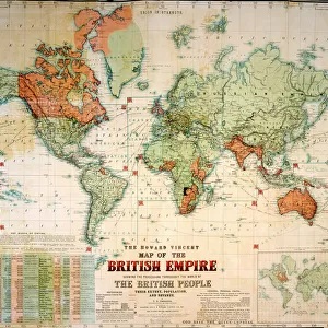
British Empire Map 1880
![]()

Wall Art and Photo Gifts from Mary Evans Picture Library
British Empire Map 1880
Map showing the extent of the British Empire circa 1880 Date: circa 1880
Mary Evans Picture Library makes available wonderful images created for people to enjoy over the centuries
Media ID 20143111
© Bubblepunk
FEATURES IN THESE COLLECTIONS
> Maps and Charts
> British Empire Maps
> Mary Evans Prints Online
> New Images July 2020
EDITORS COMMENTS
This print depicts the British Empire as it stood around the year 1880, a time when the reach of the British Crown extended to every corner of the globe. The intricate details of this map offer a glimpse into the political and historical significance of one of the most powerful and influential empires in world history. The British Empire at its height covered over 13 million square miles, spanning six continents and encompassing hundreds of territories. From the lush green lands of Canada and Australia, to the sun-soaked shores of the Caribbean and the vast expanses of Africa and Asia, the British flag flew high, symbolizing the reach and might of the British monarchy. The map serves as a testament to the era of imperialism, a period of intense global competition and expansion, as European powers vied for control over valuable resources and strategic territories. The British Empire, under the guidance of political leaders such as Prime Ministers Gladstone and Disraeli, expanded its territories through a combination of diplomacy, military conquest, and economic influence. The intricate lines and borders on this map tell a story of exploration, colonization, and the complex web of relationships and alliances that shaped the world during this time. From the strategic trade routes of the Indian Ocean to the rich natural resources of Africa and the Pacific, the British Empire played a pivotal role in shaping the modern world. This map is not only a historical artifact, but also a reminder of the profound impact that imperialism had on the world we live in today. It invites us to reflect on the legacy of the British Empire and the ways in which its influence continues to shape global politics, culture, and society.
MADE IN THE USA
Safe Shipping with 30 Day Money Back Guarantee
FREE PERSONALISATION*
We are proud to offer a range of customisation features including Personalised Captions, Color Filters and Picture Zoom Tools
SECURE PAYMENTS
We happily accept a wide range of payment options so you can pay for the things you need in the way that is most convenient for you
* Options may vary by product and licensing agreement. Zoomed Pictures can be adjusted in the Cart.


