
Maps Collection
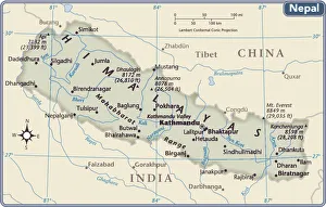
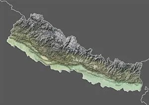
Nepal is a landlocked country located in South Asia, bordered by India and China, and is home to the world’s highest mountain, Mount Everest
Choose a picture from our Maps Collection for your Wall Art and Photo Gifts
27 items


All Professionally Made to Order for Quick Shipping
-
Maps Collection
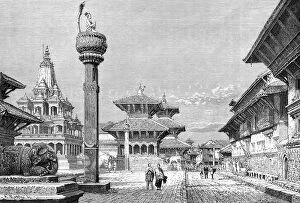
Nepal is a landlocked country located in South Asia, bordered by India and China, and is home to the world’s highest mountain, Mount Everest. Maps of Nepal are an important tool for travelers and locals alike. They show the topography of the country, its rivers and lakes, national parks, cities and towns. They also provide information about roads, airports, railway lines and other transport links. Maps of Nepal can be used to plan trips or hikes in the mountains as well as to find places of interest such as temples or monuments and are useful for locating areas prone to natural disasters such as earthquakes or landslides so that people can stay safe during their travels.
+
Our beautiful pictures are available as Framed Prints, Photos, Wall Art and Photo Gifts
The Maps of Nepal Asia collection from Media Storehouse offers a stunning array of wall art and framed prints that showcase the beauty and diversity of Nepal's geography. This unique collection features maps that depict various regions, cities, and landmarks throughout the country, including Kathmandu Valley, Mount Everest, Annapurna Circuit Trekking Route, and more. Each print is carefully crafted using high-quality materials to ensure long-lasting durability and vibrant colors. The Maps of Nepal Asia collection is perfect for anyone who loves travel or has an interest in geography. These prints make great additions to any home or office decor. Whether you're looking for a beautiful piece of artwork to hang on your wall or want to give a thoughtful gift to someone special in your life, the Maps of Nepal Asia collection from Media Storehouse is sure to impress. With its stunning visuals and attention to detail, our collection captures the essence of one of Asia's most fascinating countries like never before.
+
What are Maps of Nepal Asia art prints?
Maps of Nepal Asia art prints are high-quality reproductions of maps depicting the geography and topography of Nepal, a country located in South Asia. These art prints showcase intricate details such as mountain ranges, rivers, cities, and landmarks that make up the diverse landscape of Nepal. They are perfect for those who have an interest in geography or want to display their love for this beautiful country. These maps come in various sizes and styles to suit different preferences. Some feature antique designs while others have a modern touch with vibrant colors. They can be framed or hung on walls as standalone pieces or combined with other artworks to create a unique gallery wall. Maps of Nepal Asia art prints are not only decorative but also informative. They provide valuable information about the terrain and features of Nepal that may be useful for educational purposes or travel planning. These art prints are an excellent addition to any home or office space looking to add some cultural flair while celebrating the beauty of Nepal's natural landscapes.
+
What Maps of Nepal Asia art prints can I buy from Media Storehouse?
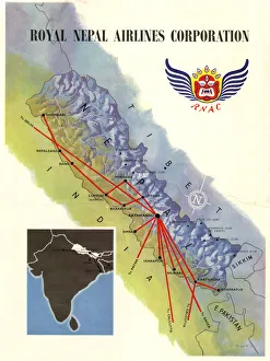
We offer a wide range of Maps of Nepal Asia art prints that are perfect for those who love to explore and discover new places. These maps showcase the intricate details of Nepal's topography, including its mountain ranges, rivers, lakes, and cities. You can choose from different styles and designs such as vintage maps or contemporary ones that feature vibrant colors. Some popular options include the detailed topographic map of Mount Everest region which shows all the trekking routes in the area. Another option is a colorful political map that highlights all the provinces and districts in Nepal with their respective capitals. These Maps of Nepal Asia art prints are available in various sizes to suit your needs. They make great additions to any home or office space, adding an element of adventure and culture to your decor. Whether you're a traveler or simply appreciate beautiful artwork, these maps are sure to impress.
+
How do I buy Maps of Nepal Asia art prints?
To buy Maps of Nepal Asia art prints from Media Storehouse, you can browse our extensive collection online. Simply search for "Maps of Nepal Asia" in the search bar on our website and select the print that catches your eye. Once you have found a print you like, click on it to view more details about the product. From there, add the item to your cart and proceed to checkout. You will be prompted to enter your shipping information and payment details before finalizing your order. We offer high-quality art prints that are perfect for adding a touch of culture and beauty to any space. Whether you're looking for a statement piece or something subtle, they have a wide range of options available. Buying Maps of Nepal Asia art prints from Media Storehouse is easy and convenient – simply find what you like online, add it to your cart, and complete your purchase.
+
How much do Maps of Nepal Asia art prints cost?
We offer a wide range of Maps of Nepal Asia art prints at varying prices. Our collection includes both modern and vintage maps that are perfect for home decor or as gifts. The cost of our Maps of Nepal Asia art prints depends on the size, quality, and type of print you choose. We have options ranging from small posters to large canvas prints that can fit any budget. Our prints are made using high-quality materials to ensure they last for years without fading or losing their vibrancy. Our selection also includes different styles such as antique maps, topographical maps, political maps, and more. You can find the perfect map to suit your taste and style preferences in our extensive collection. Whether you're looking for a unique piece of wall art or want to add some character to your living space with a vintage map, we have something for everyone at affordable prices.
+
How will my Maps of Nepal Asia art prints be delivered to me?
We take great care in ensuring that your Maps of Nepal Asia art prints are delivered to you safely and securely. We use high-quality packaging materials to protect your artwork during transit. Your order will be carefully packaged and dispatched from our warehouse using a reliable courier service. We offer a range of delivery options for our customers, including standard delivery and express delivery. You can choose the option that best suits your needs at checkout. Once your order has been dispatched, you will receive an email notification with tracking information so that you can monitor the progress of your shipment. We pride ourselves on providing excellent customer service and delivering high-quality products to our customers. If you have any questions or concerns about the delivery of your Maps of Nepal Asia art prints, please do not hesitate to contact us and we will be happy to assist you in any way we can.