
Maps Collection
Maps of Bangladesh Asia are essential for understanding the geography and topography of this region
Choose a picture from our Maps Collection for your Wall Art and Photo Gifts
22 items


All Professionally Made to Order for Quick Shipping
-
Maps Collection
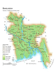
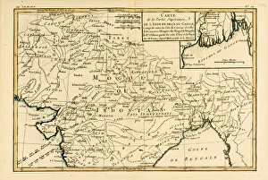
Maps of Bangladesh Asia are essential for understanding the geography and topography of this region. Bangladesh is a country located in South Asia, bordered by India to the west, north and east, and Myanmar to the southeast and has a population of over 160 million people, making it one of the most densely populated countries in the world. Maps of Bangladesh Asia provide an overview of its landforms, rivers, cities and towns. They also show its major roads and highways as well as its international borders with India and Myanmar. Additionally they can be used to identify important landmarks such as historical sites or places of interest for tourists visiting this region and can an invaluable tool for anyone looking to explore or gain a better understanding about Bangladesh Asia's physical features or cultural heritage.
+
Our beautiful pictures are available as Framed Prints, Photos, Wall Art and Photo Gifts
Media Storehouse offers a collection of Maps of Bangladesh Asia that showcases the country's geography and topography. Our collection features various maps, including political, physical, and satellite images that highlight the different regions in Bangladesh. These maps are available as wall art and framed prints. The Maps of Bangladesh Asia collection provides an excellent opportunity for people to learn about the country's diverse landscape and its cultural heritage. The maps also offer insights into the economic activities taking place in different parts of the country. Media Storehouse ensures that all their products are made from high-quality materials to ensure durability and longevity. Customers can choose from a range of sizes to suit their preferences. Our collection is ideal for anyone interested in learning more about Bangladesh or looking for unique decor pieces for their home or office space. With our vast selection of Maps of Bangladesh Asia, customers can find something that suits their taste and budget easily.
+
What are Maps of Bangladesh Asia art prints?
Maps of Bangladesh Asia art prints are high-quality reproductions of maps that depict the geography and topography of Bangladesh, a country located in South Asia. These prints showcase intricate details such as rivers, mountains, cities, and landmarks that make up the diverse landscape of this beautiful country. They are perfect for anyone who has an interest in history or geography or wants to add a unique piece of artwork to their home or office. These art prints come in various sizes and can be printed on different materials such as canvas or paper. They are created using advanced printing technology that ensures vibrant colors and sharp details. Maps of Bangladesh Asia art prints offer a fascinating glimpse into the rich culture and heritage of this region while also serving as decorative pieces that can enhance any living space. Whether you're looking for a gift for someone special or want to decorate your own walls with something meaningful, these maps provide an excellent option for those interested in exploring the world through art.
+
What Maps of Bangladesh Asia art prints can I buy from Media Storehouse?
We offer a wide range of Maps of Bangladesh Asia art prints that you can buy. These maps are available in various sizes and styles, including vintage, modern, and artistic designs. You can choose from different types of maps such as political maps, physical maps, topographic maps, and more. The Maps of Bangladesh Asia art prints offered by Media Storehouse are perfect for anyone who loves geography or wants to decorate their home or office with unique artwork. They are printed on high-quality paper using state-of-the-art printing technology to ensure that the colors remain vibrant for years to come. Whether you're looking for a map of Dhaka city or want to explore the beautiful landscapes of Bangladesh's countryside, we have something for everyone. With so many options available at your fingertips, it's easy to find the perfect Maps of Bangladesh Asia art print that suits your taste and style.
+
How do I buy Maps of Bangladesh Asia art prints?
To buy Maps of Bangladesh Asia art prints from Media Storehouse, you can browse our extensive collection of maps online. Once you have found the map that you want to purchase, simply add it to your cart and proceed to checkout. You will be prompted to enter your shipping and payment information before completing your order. We offer a variety of sizes for their Maps of Bangladesh Asia art prints, so make sure to select the size that best fits your needs. We also offer different framing options if you prefer a framed print. If you have any questions about the ordering process or need assistance with selecting a map, we have customer service representatives available via phone or email who can help guide you through the process. Buying Maps of Bangladesh Asia art prints from Media Storehouse is an easy and convenient way to add beautiful artwork to your home or office decor.
+
How much do Maps of Bangladesh Asia art prints cost?
We offer a wide range of Maps of Bangladesh Asia art prints at varying prices. Our collection includes high-quality prints that are perfect for adding a touch of elegance to any room or office space. The cost of our Maps of Bangladesh Asia art prints is determined by several factors such as the size, framing options, and materials used. We understand that everyone has different preferences and budgets when it comes to purchasing artwork. That's why we have made sure to provide a diverse selection that caters to all tastes and price points. Whether you're looking for something simple or more elaborate, we have something for everyone. Our Maps of Bangladesh Asia art prints are created using state-of-the-art printing technology and premium quality materials to ensure they stand the test of time. So if you're looking for beautiful wall decor that celebrates the beauty and culture of Bangladesh in an artistic way, look no further than Media Storehouse.
+
How will my Maps of Bangladesh Asia art prints be delivered to me?
Your Maps of Bangladesh Asia art prints will be delivered to you in a safe and secure manner. We take great care in packaging our products to ensure that they arrive at your doorstep undamaged. Our delivery partners are reliable and efficient, ensuring that your order is delivered on time. We offer various delivery options depending on your location and preferences. You can choose standard or express shipping, with tracking available for both options. We also provide international shipping for customers outside of the UK. Once your order has been dispatched, we will send you an email confirmation along with a tracking number so that you can track the progress of your shipment online. We pride ourselves on delivering high-quality products and exceptional customer service. If you have any questions or concerns about the delivery of your Maps of Bangladesh Asia art prints, please do not hesitate to contact us and we will be happy to assist you.