Home > Europe > Greece > Maps
Photo Mug : Map / Europe / Greece 323Bc


![]()
Home Decor from Mary Evans Picture Library
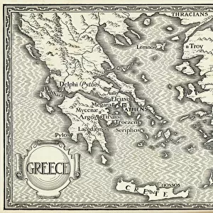
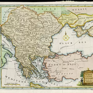
Map / Europe / Greece 323Bc
the Empire of Alexander
Mary Evans Picture Library makes available wonderful images created for people to enjoy over the centuries
Media ID 594369
© Mary Evans Picture Library 2015 - https://copyrighthub.org/s0/hub1/creation/maryevans/MaryEvansPictureID/10046525
Photo Mug (11 oz)
Introducing the Media Storehouse Photo Mug, a unique and thoughtful gift that lets you take your favorite images with you everywhere you go. This mug features an stunning historical image of "Map / Europe / Greece 323BC" by Mary Evans Picture Library from Mary Evans Prints Online, showcasing the Empire of Alexander the Great. This high-quality mug not only keeps your beverages warm but also adds a touch of history and culture to your daily routine. Perfect for history enthusiasts or anyone who appreciates beautiful art, this mug is sure to become a cherished addition to your collection. Embrace the past and start your day with a cup of inspiration.
A personalized photo mug blends sentimentality with functionality, making an ideal gift for cherished loved ones, close friends, or valued colleagues. Preview may show both sides of the same mug.
Elevate your coffee or tea experience with our premium white ceramic mug. Its wide, comfortable handle makes drinking easy, and you can rely on it to be both microwave and dishwasher safe. Sold in single units, preview may show both sides of the same mug so you can see how the picture wraps around.
Mug Size is 8cm high x 9.5cm diameter (3.1" x 3.7")
These are individually made so all sizes are approximate
FEATURES IN THESE COLLECTIONS
> Maps and Charts
> Early Maps
EDITORS COMMENTS
This image transports us back in time to the ancient world of Greece, specifically during the reign of Alexander the Great in 323 BC. The map, titled "Greece, Alexander the Great, 323 BC," is a testament to the vast territories that once comprised the Macedonian Empire under the legendary ruler's command. Alexander III of Macedon, born in 356 BC in Pella, was a warrior-king who rose to power at a young age and went on to conquer a vast empire that stretched from Greece to India. This map illustrates the extent of Alexander's conquests, which included Egypt, Syria, Mesopotamia, Persia, and parts of Central Asia. The map's intricate details reveal the geographical layout of the ancient world during this period. The Aegean Sea, the Black Sea, and the Mediterranean Sea are clearly marked, as are major rivers such as the Nile, the Tigris, and the Euphrates. The map also highlights significant cities and territories that were under Alexander's control, including Athens, Sparta, Thebes, Babylon, and Alexandria. This map offers a unique perspective on the historical events that shaped the ancient world. Alexander's conquests revolutionized the world, spreading Greek culture and language far beyond the borders of Greece. His empire paved the way for the Hellenistic period, which saw the flourishing of art, philosophy, and science. As we gaze at this map, we are reminded of the rich history and cultural achievements of ancient Greece and the enduring legacy of Alexander the Great. This image is not only a beautiful work of cartography but also a window into the past, allowing us to explore the fascinating world of ancient civilizations and the remarkable story of one of history's greatest leaders.
MADE IN THE USA
Safe Shipping with 30 Day Money Back Guarantee
FREE PERSONALISATION*
We are proud to offer a range of customisation features including Personalised Captions, Color Filters and Picture Zoom Tools
SECURE PAYMENTS
We happily accept a wide range of payment options so you can pay for the things you need in the way that is most convenient for you
* Options may vary by product and licensing agreement. Zoomed Pictures can be adjusted in the Cart.