
Maps Collection
Maps of Equatorial Guinea Africa are a useful tool for understanding the geography of this small African nation
Choose a picture from our Maps Collection for your Wall Art and Photo Gifts
18 items


All Professionally Made to Order for Quick Shipping
-
Maps Collection
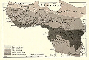
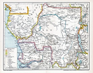
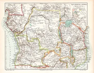
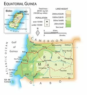
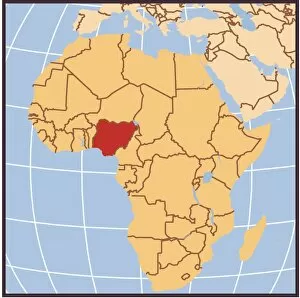
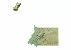
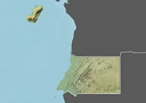
Maps of Equatorial Guinea Africa are a useful tool for understanding the geography of this small African nation. Equatorial Guinea is located on the west coast of Central Africa, bordered by Cameroon to the north and Gabon to the east and south. The country consists of two parts: a mainland region called Río Muni, and several islands including Bioko, Annobón, Corisco and Elobey Grande. Maps show that Río Muni is mostly covered in tropical rainforest while Bioko Island has more diverse terrain including mountains, hills and beaches. It also shows major cities such as Malabo (the capital), Bata (the largest city) and Ebebiyín (a port city). With its rich culture, diverse landscape and unique location on both sides of the equator, Equatorial Guinea offers visitors an interesting destination to explore.
+
Our beautiful pictures are available as Framed Prints, Photos, Wall Art and Photo Gifts
The Maps of Equatorial Guinea Africa collection from Media Storehouse offers a unique and fascinating glimpse into the geography and history of this small African nation. Featuring a variety of vintage maps, including topographical, political, and cultural representations, our collection provides an excellent resource for anyone interested in exploring Equatorial Guinea's rich cultural heritage. From detailed depictions of the country's diverse landscapes to historical maps that highlight its colonial past, these prints offer a wealth of information about Equatorial Guinea's people, culture, and natural resources. Whether you're looking to decorate your home or office with beautiful wall art or simply want to learn more about this intriguing part of Africa, the Maps of Equatorial Guinea Africa collection is sure to provide hours of enjoyment and education. So why wait? Browse our selection today and discover all that this amazing country has to offer.
+
What are Maps of Equatorial Guinea Africa art prints?
Maps of Equatorial Guinea Africa art prints are high-quality reproductions of maps depicting the geography and topography of the African country, Equatorial Guinea. These art prints showcase various aspects of the region's landscape, including rivers, mountains, forests, and cities. They also feature important landmarks such as national parks and reserves. These maps are not only useful for navigation purposes but also serve as decorative pieces that can add a touch of sophistication to any room. They are perfect for individuals who have an interest in history or geography or those who want to display their love for Africa. The Maps of Equatorial Guinea Africa art prints come in different sizes and styles to suit individual preferences. Some may prefer vintage-style maps while others may opt for more modern designs. Regardless of style choice, these art prints offer a unique way to appreciate the beauty and diversity found within Equatorial Guinea's borders.
+
What Maps of Equatorial Guinea Africa art prints can I buy from Media Storehouse?
We offer a wide range of Equatorial Guinea Africa art prints that you can buy. These maps are perfect for those who love geography or want to decorate their homes with unique and interesting pieces. You can choose from different types of maps, such as political or physical maps, depending on your preference. The Equatorial Guinea Africa art prints available at Media Storehouse come in various sizes and formats, including canvas prints, framed prints, and photographic prints. The quality of these products is exceptional, ensuring that the colors are vibrant and the details are sharp. Whether you're looking for a map to hang in your living room or office space, we have something for everyone. These maps make great gifts for friends or family members who have an interest in geography or African culture. If you're looking to purchase high-quality Equatorial Guinea Africa art prints from a reputable company like Media Storehouse, then look no further than our extensive collection of beautiful map designs.
+
How do I buy Maps of Equatorial Guinea Africa art prints?
To buy Maps of Equatorial Guinea Africa art prints, you can visit our online marketplace. The website offers a vast collection of high-quality art prints that are sourced from various artists and photographers worldwide. You can search for the specific map print you want by using the search bar or browsing through the categories provided on the site. Once you have found your desired print, click on it to view its details and select your preferred size before adding it to your cart. After completing your purchase, Media Storehouse will process your order and ship it to your address. Buying Maps of Equatorial Guinea Africa art prints from Media Storehouse is an excellent way to decorate any space with unique artwork while also supporting independent artists and photographers. With their extensive selection and easy-to-use platform, finding and purchasing the perfect map print has never been easier.
+
How much do Maps of Equatorial Guinea Africa art prints cost?
We offer a wide range of Equatorial Guinea Africa art prints that showcase the beauty and diversity of this African country. Our collection includes maps of Equatorial Guinea in various styles and sizes, each capturing the unique features of this nation. The cost of our maps of Equatorial Guinea Africa art prints varies depending on factors such as size, style, and finish. However, we strive to provide affordable prices for all our customers without compromising on quality. Our team is dedicated to providing you with high-quality products that meet your needs and exceed your expectations. We take pride in offering a diverse selection of artwork that celebrates different cultures from around the world. Whether you're looking for a small map print or a large canvas piece to display in your home or office, we have something for everyone at Media Storehouse. So why not explore our collection today and discover the perfect map print for you?
+
How will my Maps of Equatorial Guinea Africa art prints be delivered to me?
We take great care in ensuring that your Maps of Equatorial Guinea Africa art prints are delivered to you safely and securely. We use high-quality packaging materials to protect your artwork during transit and ensure it arrives in pristine condition. Your art prints will be carefully rolled up and placed inside a sturdy cardboard tube for delivery. This ensures that the print remains flat and undamaged during transportation. The package will also include instructions on how to unroll the print without causing any damage. We work with trusted courier partners who specialize in delivering fragile items such as artwork. You can track your delivery online using the tracking number provided once your order has been dispatched. We understand how important it is for our customers to receive their orders promptly and in perfect condition. That's why we go above and beyond to ensure that every order is handled with care from start to finish.