Home > Animals > Mammals > Soricidae > Navigator
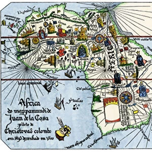
AFRICA: MAP, 15th CENTURY. Tabula Nova Partis Africae

![]()
Wall Art and Photo Gifts from Granger
AFRICA: MAP, 15th CENTURY. Tabula Nova Partis Africae
AFRICA: MAP, 15th CENTURY.
Tabula Nova Partis Africae. A late 15th century map of Africa from the Cosmographia of Ptolemy, showing the headlands and rivers with names given by Portuguese navigators. The unknown has been filled in with mythical data
Granger holds millions of images spanning more than 25,000 years of world history, from before the Stone Age to the dawn of the Space Age
Media ID 12321006
15th Century Africa African Age Of Exploration Claudius Coast Cosmographia Universalis Exploration Imaginary Mountain Myth New World Portuguese Ptolemy Scepter Seashore Southern
FEATURES IN THESE COLLECTIONS
> Africa
> Related Images
> Animals
> Mammals
> Soricidae
> Navigator
> Arts
> Landscape paintings
> Waterfall and river artworks
> River artworks
> Granger Art on Demand
> Maps
> Maps and Charts
> World
EDITORS COMMENTS
This print takes us back to the 15th century, offering a glimpse into the exploration and discovery of Africa during the Age of Exploration. The map, known as Tabula Nova Partis Africae, is derived from Ptolemy's Cosmographia and showcases both real and mythical elements. Portuguese navigators have left their mark on this map by providing names for headlands and rivers they encountered during their expeditions. As we study this intricate piece of cartography, we are reminded of the vast unknown that once shrouded Africa. Mythical data fills in these uncharted territories, fueling our imagination with tales yet to be unraveled. Mountains rise majestically while rivers meander through lush landscapes, inviting us to embark on our own journey of discovery. The presence of a king holding a scepter signifies power and authority over these lands. The coastline stretches along the seashore, hinting at potential trade routes that would shape future interactions between continents. This Renaissance-era map not only serves as a historical artifact but also highlights the spirit of exploration that defined an era. It represents an intersection between reality and myth – where ancient knowledge meets newfound curiosity about distant lands. Whether you are fascinated by African history or drawn to the allure of exploration itself, this remarkable print offers a window into an age when maps were gateways to untold adventures in far-flung corners of the world.
MADE IN THE USA
Safe Shipping with 30 Day Money Back Guarantee
FREE PERSONALISATION*
We are proud to offer a range of customisation features including Personalised Captions, Color Filters and Picture Zoom Tools
SECURE PAYMENTS
We happily accept a wide range of payment options so you can pay for the things you need in the way that is most convenient for you
* Options may vary by product and licensing agreement. Zoomed Pictures can be adjusted in the Cart.