Home > Europe > Belgium > Bruges
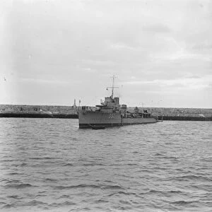
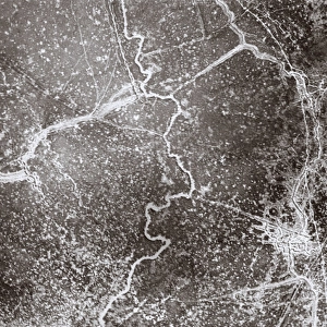
Aerial photograph of Zeebrugge, Belgium, during WW1

![]()
Poster Prints from Mary Evans Picture Library
Aerial photograph of Zeebrugge, Belgium, during WW1
Aerial photograph (British) of the sea port of Zeebrugge, Belgium, taken from a height of 17, 000 feet in a DHA (De Havilland). The harbour was later the site of the Zeebrugge Raid on 23 April 1918, when the British Royal Navy put the nearby German inland naval base at Bruges out of action. Date: July 1917
Mary Evans Picture Library makes available wonderful images created for people to enjoy over the centuries
Media ID 7181957
© Mary Evans Picture Library 2015 - https://copyrighthub.org/s0/hub1/creation/maryevans/MaryEvansPictureID/10528327
Belgian Bruges Havilland Inland Raid Zeebrugge Base
FEATURES IN THESE COLLECTIONS
> Aerial Photography
> Belgium
> Aerial Photography
> Germany
> Aerial Photography
> Related Images
> Europe
> Belgium
> Related Images
> Historic
> World War I and II
> Naval warfare
> Services
> Royal Navy
EDITORS COMMENTS
1. Title: Aerial View of Zeebrugge Harbor, Belgium, during World War I Description: This evocative aerial photograph captures the tranquil yet strategic scene of the Zeebrugge Harbor in Belgium during July 1917. Taken from an impressive altitude of 17,000 feet aboard a De Havilland aircraft, the image offers a unique perspective of the bustling coastal area. At the time, the harbor was a vital hub for maritime activities, and its calm waters and expansive dockyards were a testament to the region's economic importance. Background: Unbeknownst to the unsuspecting German forces, this seemingly peaceful harbor would soon become the target of a daring British naval operation. On April 23, 1918, the Royal Navy launched the Zeebrugge Raid, aiming to put the nearby German inland naval base at Bruges out of action. The success of this mission would significantly impact the outcome of World War I by denying the Germans access to their formidable U-boat fleet, which had been wreaking havoc on Allied shipping lines. The photograph serves as a poignant reminder of the strategic importance of this coastal location during the war. The image's crisp details and clear contrasts reveal the intricate layout of the harbor, with its numerous ships, dockyards, and buildings, all nestled along the Belgian coastline. The serene waters, dotted with vessels of various sizes, contrast sharply with the looming threat of conflict that was about to unfold in this very place just a few months later. This aerial photograph is an essential historical record of the Zeebrugge Harbor during World War I, offering a unique glimpse into the strategic landscape that played a pivotal role in the conflict.
MADE IN THE USA
Safe Shipping with 30 Day Money Back Guarantee
FREE PERSONALISATION*
We are proud to offer a range of customisation features including Personalised Captions, Color Filters and Picture Zoom Tools
FREE COLORIZATION SERVICE
You can choose advanced AI Colorization for this picture at no extra charge!
SECURE PAYMENTS
We happily accept a wide range of payment options so you can pay for the things you need in the way that is most convenient for you
* Options may vary by product and licensing agreement. Zoomed Pictures can be adjusted in the Cart.