Home > Arts > Artists > B > Martin Behaim
Framed Print : World Map / Behaim 1492


![]()
Framed Photos from Mary Evans Picture Library
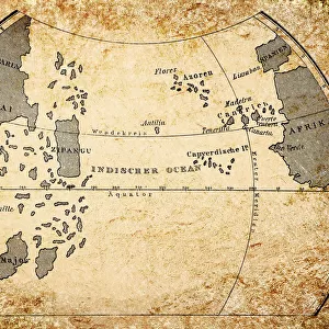
World Map / Behaim 1492
Map of the world in two halves, according to Martin Behaim
Mary Evans Picture Library makes available wonderful images created for people to enjoy over the centuries
Media ID 608729
© Mary Evans Picture Library 2015 - https://copyrighthub.org/s0/hub1/creation/maryevans/MaryEvansPictureID/10113673
1492 Halves Maps Martin Behaim
22"x18" Modern Frame
Introducing the stunning addition to our Media Storehouse Framed Prints collection: the World Map / Behaim 1492. This captivating piece showcases an intricately detailed representation of the world as it was believed to be known in 1492, according to the renowned cartographer Martin Behaim. Each half of the map is meticulously framed, preserving the rich history and intrigue of this ancient artifact. Bring the spirit of exploration and discovery into your home or office with this impressive and unique work of art.
20x16 Print in an MDF Wooden Frame with 180 gsm Satin Finish Paper. Glazed using shatter proof thin plexiglass. Frame thickness is 1 inch and depth 0.75 inch. Fluted cardboard backing held with clips. Supplied ready to hang with sawtooth hanger and rubber bumpers. Spot clean with a damp cloth. Packaged foam wrapped in a card.
Contemporary Framed and Mounted Prints - Professionally Made and Ready to Hang
Estimated Image Size (if not cropped) is 50.8cm x 45.7cm (20" x 18")
Estimated Product Size is 55.9cm x 45.7cm (22" x 18")
These are individually made so all sizes are approximate
Artwork printed orientated as per the preview above, with landscape (horizontal) orientation to match the source image.
FEATURES IN THESE COLLECTIONS
> Arts
> Artists
> B
> Martin Behaim
> Maps and Charts
> Early Maps
> Maps and Charts
> World
EDITORS COMMENTS
This stunning World Map, created in 1492 by the Nuremberg cartographer Martin Behaim, is a testament to the fascinating and complex history of cartography during the Age of Discovery. The map is unique in its representation of the world as divided into two distinct halves, with the eastern and western hemispheres separated by the Indian Ocean. Behaim, who is believed to have traveled extensively, incorporated the latest geographical knowledge available at the time, including the recent discovery of the New World by Christopher Columbus. The map's intricate details and vibrant colors bring to life the known world of the late 15th century, with Europe, Africa, and Asia depicted in their entirety, and the Americas, still largely unexplored, represented only by a rough outline. The map also features numerous annotations and illustrations, including depictions of various cities, islands, and mythical places. Despite its age, the Behaim World Map remains an important historical artifact, providing valuable insights into the geographical knowledge and beliefs of the time. Its intricate design and rich details continue to captivate scholars, historians, and cartography enthusiasts alike, making it a must-see for anyone interested in the history of exploration and the development of global awareness. This print, from the Mary Evans collection, offers a rare opportunity to own a piece of cartographic history, allowing us to explore the world as it was understood over 500 years ago. Whether displayed as a conversation piece in a home or office, or used as a teaching tool in an educational setting, this print is sure to inspire wonder and curiosity about the world and its rich history.
MADE IN THE USA
Safe Shipping with 30 Day Money Back Guarantee
FREE PERSONALISATION*
We are proud to offer a range of customisation features including Personalised Captions, Color Filters and Picture Zoom Tools
SECURE PAYMENTS
We happily accept a wide range of payment options so you can pay for the things you need in the way that is most convenient for you
* Options may vary by product and licensing agreement. Zoomed Pictures can be adjusted in the Cart.