Home > Europe > United Kingdom > Wales > Maps
Framed Print : Viking Britain Map


Framed Photos from Mary Evans Picture Library
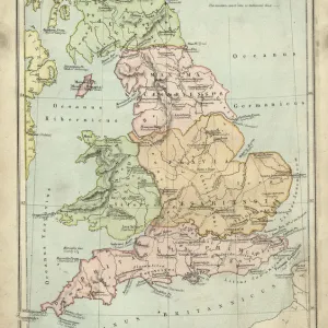
Viking Britain Map
A map of the British Isles (including Ireland) during the time of the Vikings
Mary Evans Picture Library makes available wonderful images created for people to enjoy over the centuries
Media ID 4323434
© Mary Evans Picture Library 2015 - https://copyrighthub.org/s0/hub1/creation/maryevans/MaryEvansPictureID/10168008
10th Centuries Counties Including Isles Maps Scot Land Viking Vikings
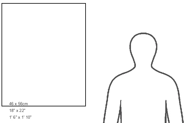
22"x18" Modern Frame
Discover the rich history of Viking Britain with our stunning Framed Prints from Media Storehouse. This captivating map, titled "Viking Britain," is brought to you by Rights Managed from Mary Evans Prints Online. It provides a fascinating insight into the British Isles during the Viking era, showcasing the extent of their reach and influence. Each print is meticulously framed with care, enhancing the intricate details of the map and adding a touch of history to your space. Bring the past to life with this beautifully presented Framed Print from Media Storehouse.
20x16 Print in an MDF Wooden Frame with 180 gsm Satin Finish Paper. Glazed using shatter proof thin plexiglass. Frame thickness is 1 inch and depth 0.75 inch. Fluted cardboard backing held with clips. Supplied ready to hang with sawtooth hanger and rubber bumpers. Spot clean with a damp cloth. Packaged foam wrapped in a card.
Contemporary Framed and Mounted Prints - Professionally Made and Ready to Hang
Estimated Image Size (if not cropped) is 36.4cm x 50.8cm (14.3" x 20")
Estimated Product Size is 45.7cm x 55.9cm (18" x 22")
These are individually made so all sizes are approximate
Artwork printed orientated as per the preview above, with portrait (vertical) orientation to match the source image.
FEATURES IN THESE COLLECTIONS
> Europe
> France
> Canton
> Landes
> Europe
> Republic of Ireland
> Maps
> Europe
> United Kingdom
> England
> Maps
> Europe
> United Kingdom
> England
> Posters
> Europe
> United Kingdom
> England
> Related Images
> Europe
> United Kingdom
> Wales
> Maps
> Europe
> United Kingdom
> Wales
> Posters
> Europe
> United Kingdom
> Wales
> Related Images
> Maps and Charts
> Early Maps
> Popular Themes
> Maps and Charts
EDITORS COMMENTS
Step back in time and explore the intriguing world of Viking Britain and Ireland, as depicted in this map from the 9th and 10th centuries. This historical cartographic representation illustrates the extent of Viking influence and settlements across the British Isles during this dynamic period in European history. The map encompasses the entirety of Britain, including England, Wales, Scotland, and Ireland. The intricate detailing reveals the division of territories into various counties, showcasing the political and cultural landscape of the time. The map also highlights the strategic locations of significant Viking settlements, such as Dublin, York, and Lindisfarne, providing a visual representation of the extensive reach of Viking explorers and conquerors. The map's creation during the late Viking Age, around the 10th century, offers a unique insight into the geographical knowledge and cartographic skills of the time. The map's accuracy is a testament to the advanced navigational abilities of the Vikings, who traveled vast distances across the North Sea and Atlantic Ocean, establishing trade networks and settlements. The map serves as a powerful reminder of the profound impact the Vikings had on the British Isles during the late medieval period. Their influence is evident in the language, art, architecture, and genealogy of the region, making this map an essential resource for students of history, archaeology, and cultural studies. This stunning print, brought to you by Mary Evans Prints Online, offers a glimpse into the rich tapestry of history that continues to captivate and inspire us. Let this map transport you to a time of adventure, exploration, and cultural exchange as you delve deeper into the fascinating history of Viking Britain and Ireland.
MADE IN THE USA
Safe Shipping with 30 Day Money Back Guarantee
FREE PERSONALISATION*
We are proud to offer a range of customisation features including Personalised Captions, Color Filters and Picture Zoom Tools
SECURE PAYMENTS
We happily accept a wide range of payment options so you can pay for the things you need in the way that is most convenient for you
* Options may vary by product and licensing agreement. Zoomed Pictures can be adjusted in the Cart.