Home > Europe > France > Canton > Bas Rhin
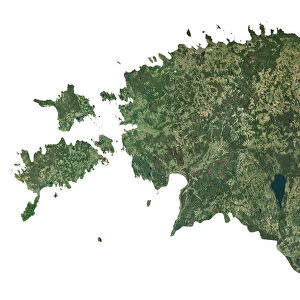
Asia, True Colour Satellite Image

![]()
Wall Art and Photo Gifts from Universal Images Group (UIG)
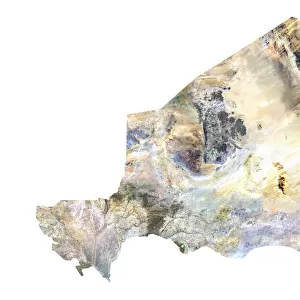
Asia, True Colour Satellite Image
Satellite view of Asia. This image was compiled from data acquired by LANDSAT satellite
Universal Images Group (UIG) manages distribution for many leading specialist agencies worldwide
Media ID 9615435
© Planet Observer
Alsace Bas Rhin Geographical Border Relief Map Satellite View
FEATURES IN THESE COLLECTIONS
> Asia
> Related Images
> Europe
> France
> Canton
> Bas Rhin
> Europe
> France
> Canton
> Rhin
> Universal Images Group (UIG)
> Universal Images Group
> Satellite and Aerial
> Planet Observer 6
EDITORS COMMENTS
This print showcases the breathtaking beauty of Asia as seen from space. The true color satellite image, compiled from data acquired by the LANDSAT satellite, offers a mesmerizing perspective of this vast and diverse continent. Stretching across the frame, Asia's stunning topography comes to life with its majestic mountains, sprawling plains, winding rivers, and expansive coastlines. The vibrant colors in this photograph highlight the rich natural landscapes that make up Asia's physical geography. From lush green forests to arid deserts and snow-capped peaks to tropical islands, every corner of this continent is represented in vivid detail. The absence of people in the image allows us to fully appreciate the untouched magnificence of these lands. As we explore this satellite view of Asia, our eyes are drawn to geographical borders that define nations and regions within this vast expanse. It serves as a reminder of both unity and diversity among Asian countries - each with its own unique culture, history, and traditions. Displayed vertically like a map on display outdoors against a clear blue sky backdrop adds an element of authenticity to this remarkable piece. This print not only captures the essence of Asia but also celebrates cartography as an art form that enables us to better understand our world
MADE IN THE USA
Safe Shipping with 30 Day Money Back Guarantee
FREE PERSONALISATION*
We are proud to offer a range of customisation features including Personalised Captions, Color Filters and Picture Zoom Tools
SECURE PAYMENTS
We happily accept a wide range of payment options so you can pay for the things you need in the way that is most convenient for you
* Options may vary by product and licensing agreement. Zoomed Pictures can be adjusted in the Cart.