Home > Europe > Portugal > Maps
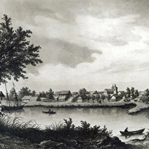
Mouse Mat : Trade / Canonor 1572


![]()
Home Decor from Mary Evans Picture Library
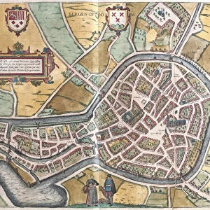
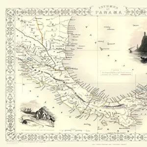
Trade / Canonor 1572
A view of CANONOR, one of the portuguese settlements on the route to Asia. Part of a larger map showing Calechut (Calcutta)/Ormus/Canonor/Mina
Mary Evans Picture Library makes available wonderful images created for people to enjoy over the centuries
Media ID 591170
© Mary Evans Picture Library 2015 - https://copyrighthub.org/s0/hub1/creation/maryevans/MaryEvansPictureID/10168824
1572 Barge Calcutta Imperialism Larger Mina Portuguese Route Settlements
Mouse Pad
Standard Size Mouse Pad 7.75" x 9..25". High density Neoprene w linen surface. Easy to clean, stain resistant finish. Rounded corners.
Archive quality photographic print in a durable wipe clean mouse mat with non slip backing. Works with all computer mice
Estimated Product Size is 23.7cm x 20.2cm (9.3" x 8")
These are individually made so all sizes are approximate
Artwork printed orientated as per the preview above, with landscape (horizontal) orientation to match the source image.
FEATURES IN THESE COLLECTIONS
> Europe
> Portugal
> Related Images
> Maps and Charts
> Early Maps
EDITORS COMMENTS
This 16th century map print, sourced from Mary Evans Picture Library, offers a historical glimpse into the maritime world of the late Portuguese Empire. The focus of the image is on Canonor, one of the Portuguese settlements along the route to Asia. Canonor, also known as Cannanore or Kannur, is located on the Malabar Coast in present-day Kerala, India. The map, which is part of a larger document, also includes Calcutta (Calechut), Ormus (Jask), and Mina (Mombasa), providing a broader perspective of the trading routes and Portuguese presence in the Indian Ocean during the Age of Discoveries. The image showcases a view of Canonor, with a Portuguese ship anchored in the harbor and a barge underway, suggesting the bustling trade activities that took place in this strategic location. Imperialism and exploration were the driving forces behind the Portuguese expansion in the 16th century, and this map offers a visual representation of their reach and influence. The Portuguese, under the leadership of Vasco da Gama, had established a sea route from Europe to India, opening up new opportunities for trade and cultural exchange. The settlements along the way, including Canonor, served as crucial stops for restocking supplies, repairing ships, and securing alliances with local rulers. This map print is a testament to the rich history of maritime trade and the enduring impact of European imperialism on the world. Its intricate details and historical significance make it an invaluable resource for scholars, historians, and anyone interested in the exploration and discovery of new lands and cultures.
MADE IN THE USA
Safe Shipping with 30 Day Money Back Guarantee
FREE PERSONALISATION*
We are proud to offer a range of customisation features including Personalised Captions, Color Filters and Picture Zoom Tools
SECURE PAYMENTS
We happily accept a wide range of payment options so you can pay for the things you need in the way that is most convenient for you
* Options may vary by product and licensing agreement. Zoomed Pictures can be adjusted in the Cart.