Home > Maps and Charts > Early Maps
Canvas Print : The Admiralty Chart of the Arctic Region, 1875


![]()
Canvas Prints from Mary Evans Picture Library
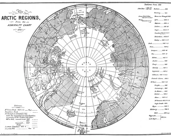
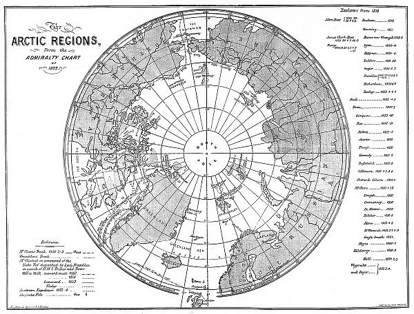
The Admiralty Chart of the Arctic Region, 1875
Engraving showing a map of the Arctic region, produced by the British Admiralty in 1875. Although mostly complete, the blank area around the North Pole shows the area that had not yet been visited and charted by explorers
Mary Evans Picture Library makes available wonderful images created for people to enjoy over the centuries
Media ID 4386289
© Mary Evans Picture Library 2015 - https://copyrighthub.org/s0/hub1/creation/maryevans/MaryEvansPictureID/10217701
1875 Admiralty Arctic Area Blank Chart Charted Complete Explorers Pole Produced Region Visited
20"x16" (51x41cm) Canvas Print
Discover the enchanting allure of the Arctic with our exquisite Canvas Prints from Media Storehouse, featuring the iconic "Admiralty Chart of the Arctic Region, 1875." This captivating engraving, sourced from Mary Evans Prints Online, offers a glimpse into the rich history of Arctic exploration. Produced by the British Admiralty in 1875, this meticulously detailed map showcases the known territories of the Arctic at the time, with the intriguing blank area around the North Pole representing the unexplored and unknown. Bring the mystery and wonder of the Arctic into your home or office with this stunning, high-quality Canvas Print.
Delivered stretched and ready to hang our premium quality canvas prints are made from a polyester/cotton blend canvas and stretched over a 1.25" (32mm) kiln dried knot free wood stretcher bar. Packaged in a plastic bag and secured to a cardboard insert for safe transit.
Canvas Prints add colour, depth and texture to any space. Professionally Stretched Canvas over a hidden Wooden Box Frame and Ready to Hang
Estimated Product Size is 50.8cm x 40.6cm (20" x 16")
These are individually made so all sizes are approximate
Artwork printed orientated as per the preview above, with landscape (horizontal) orientation to match the source image.
EDITORS COMMENTS
This fascinating print showcases "The Admiralty Chart of the Arctic Region, 1875," an engraving produced by the British Admiralty over a century ago. The map provides a detailed look at the Arctic region as it was known in the late 19th century, with most areas fully charted and explored. However, what makes this particular piece so intriguing is the blank space surrounding the North Pole - an area that had not yet been visited or documented by explorers at that time.
The historical significance of this engraving cannot be overstated, as it offers a glimpse into a period when much of the world remained uncharted and mysterious. It serves as a reminder of the brave men who ventured into unknown territories in search of knowledge and discovery.
As we study this map today, we are reminded of how far we have come in our understanding of the world around us. The import of such historical artifacts lies not only in their beauty but also in their ability to transport us back in time and inspire wonder at the vastness and complexity of our planet.
"The Admiralty Chart of the Arctic Region, 1875" is more than just a map - it is a window into history, inviting us to explore and appreciate the achievements of those who came before us.
MADE IN THE USA
Safe Shipping with 30 Day Money Back Guarantee
FREE PERSONALISATION*
We are proud to offer a range of customisation features including Personalised Captions, Color Filters and Picture Zoom Tools
FREE COLORIZATION SERVICE
You can choose advanced AI Colorization for this picture at no extra charge!
SECURE PAYMENTS
We happily accept a wide range of payment options so you can pay for the things you need in the way that is most convenient for you
* Options may vary by product and licensing agreement. Zoomed Pictures can be adjusted in the Cart.