Home > Africa > South Africa > Maps
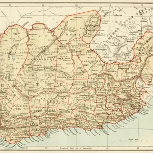
South Africa - President Kruger and General Joubert

![]()
Wall Art and Photo Gifts from Mary Evans Picture Library
South Africa - President Kruger and General Joubert
A map of the Transvaal and the Orange Free State, South Africa and two inset portraits of the Boer President Paul Kruger and Boer Commandant-General of the South African Republic, Piet Joubert
Mary Evans Picture Library makes available wonderful images created for people to enjoy over the centuries
Media ID 4407089
© Mary Evans Picture Library 2015 - https://copyrighthub.org/s0/hub1/creation/maryevans/MaryEvansPictureID/10285389
Boer Free Johannesburg Joubert Kruger Leaders Piet Southern Transvaal
FEATURES IN THESE COLLECTIONS
> Africa
> South Africa
> Johannesburg
> Africa
> South Africa
> Maps
> Maps and Charts
> Early Maps
EDITORS COMMENTS
This striking print captures the historical significance of the South African Republic, also known as the Transvaal and the Orange Free State, during the late 19th century. At the heart of the map, the two major Boer states are depicted, each with their distinctive colors and borders. Inset portraits gracefully frame the map, showcasing the prominent figures of the era: President Paul Kruger and General Piet Joubert. Paul Kruger (1825-1904) was a Dutch-speaking South African farmer and politician who served as the President of the South African Republic, also known as the Transvaal Republic, from 1883 to 1900. Kruger's leadership was marked by his staunch opposition to British encroachment on Boer lands. His tenure culminated in the Second Boer War (1899-1902), which saw the eventual defeat of the Boer republics and the annexation of their territories by the British. Piet Joubert (1834-1900) was a Boer military leader and the Commandant-General of the South African Republic from 1881 to 1883. He is best known for his role in the First Boer War (1880-1881), during which the Boers successfully defended their lands against British forces. Joubert's military prowess and strategic acumen made him a formidable adversary for the British, and his legacy continues to be celebrated in South African history. The map and portraits offer a captivating glimpse into a pivotal moment in South African history, when the Boer republics stood against the expanding British Empire. The image serves as a poignant reminder of the complex political landscape of the late 19th century and the indomitable spirit of the Boer leaders who fought for their independence.
MADE IN THE USA
Safe Shipping with 30 Day Money Back Guarantee
FREE PERSONALISATION*
We are proud to offer a range of customisation features including Personalised Captions, Color Filters and Picture Zoom Tools
SECURE PAYMENTS
We happily accept a wide range of payment options so you can pay for the things you need in the way that is most convenient for you
* Options may vary by product and licensing agreement. Zoomed Pictures can be adjusted in the Cart.